Catalog Archive
Auction 182, Lot 253

Scarce Scottish Edition Based on Ellicott's Plan of Washington, D.C.

"Plan of the City of Washington in the Territory of Columbia Ceded by the States of Virginia and Maryland to the United States of America and By Them Established as the Seat of Their Government After the Year MDCCC", Ellicott, Andrew

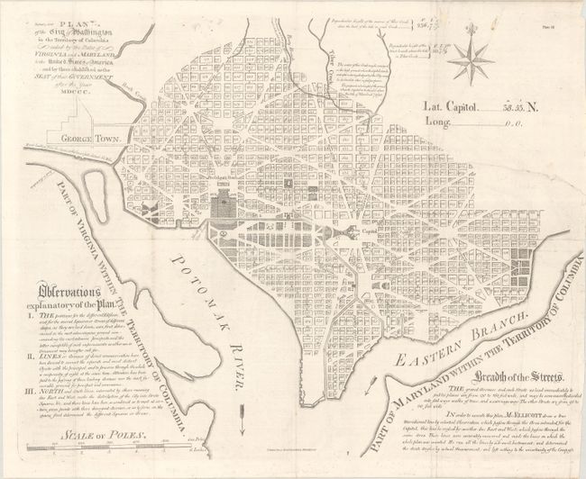
Subject: Washington, D.C.

Period: 1796 (circa)

Publication: Encyclopaedia Perthensis…

Color: Black & White

Size:
19.4 x 15.5 inches
49.3 x 39.4 cm
Download High Resolution Image
(or just click on image to launch the Zoom viewer)

Scarce edition based on Ellicott's original plan of Washington , which was first published in Boston and Philadelphia in 1792. This Scottish edition is very nearly identical to the edition printed in Boston and engraved by Samuel Hill with the title at top left. It differs in a couple small details; it does not have Hill's imprint under the title, nor does it have the small decorative line beneath the date. The paper is watermarked with the date 1794 and Encyclopaedia Perthensis is imprinted at bottom center. The plan shows the original design for the city by French architect and Revolutionary War veteran Pierre-Charles L’Enfant , focusing on the Capitol building and the President's House. Georgetown is simply outlined. The Encyclopaedia Perthensis or Universal Dictionary of Knowledge was published in Perth in sections between 1796-1806.

Ellicott's survey is considered the official plan of Washington, D.C. The plan shows the layout of streets including the long diagonals. Washington is bordered by the Potomak (Potomac) River and the Eastern Branch, now the Anacostia River. Georgetown, at the left and northwest of Rock Creek, is separately labeled. Reedy Branch and Tiber Creek are shown to the north outside of the street pattern. Each block is numbered, and there are soundings in the rivers. A few major buildings including the Capitol and the Presidents House are labeled; others are merely outlined. The proposed landscape design for the Mall is shown with considerable detail. Outline contours of docks and slips are shown along the rivers along with numerous soundings. Near the upper right is an eight-pointed compass rose surmounted by a fleur-de-lis. At the lower left is a distance Scale of Poles.

References: cf. Wheat and Brun #530; cf. Phillips (DC) #PW17.

Condition: B+

Issued folding, now flat, on a bright watermarked sheet with some professional repairs on verso, including a 7.5" edge tear at right and a few small abrasions. There are a few printer's creases and minor offsetting.

Estimate: $2,400 - $3,000

Sold for: $1,500

Closed on 4/28/2021

Archived