Catalog Archive
Auction 182, Lot 20

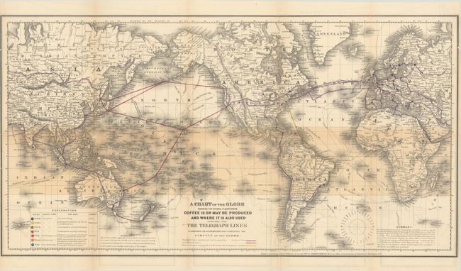
"A Chart of the Globe Showing the Several Places Where Coffee Is or May Be Produced and Where It Is Also Used Together with the Telegraph Lines in Operation or Contemplated for Completing the Circuit of the Globe",

Subject: World, Coffee

Period: 1872 (dated)

Publication:

Color: Hand Color

Size:
25.6 x 13.6 inches
65 x 34.5 cm
Download High Resolution Image
(or just click on image to launch the Zoom viewer)

This unusual map was created by Robert Hewitt and issued in his book Coffee: Its History, Cultivation, and Uses. It presents the world on Mercator's Projection with a key at lower left identifying which regions can grow coffee and how much the local inhabitants consume it. Most of the American cities are shown with red dots, indicating that "consumption is rapidly increasing." Text at bottom right states that the increase in coffee consumption "proves that the beverage is fast becoming one of the universal necessities of civilized life." Unrelated to coffee, the map curiously also locates telegraph lines, contemplated telegraph lines, and routes of steamers.

References:

Condition: B

Issued folding with a number of short fold separations closed on verso with archival tape and some minor loss at the left fold junction. An adjacent 3.5" tear has also been archivally repaired on verso. Trimmed to the border at left with a narrow right side margin.

Estimate: $240 - $300

Sold for: $300

Closed on 4/28/2021

Archived