Catalog Archive
Auction 181, Lot 313

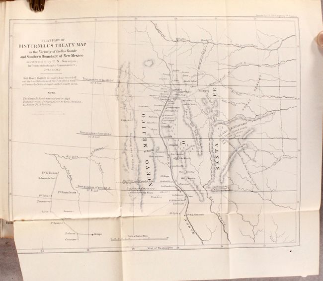
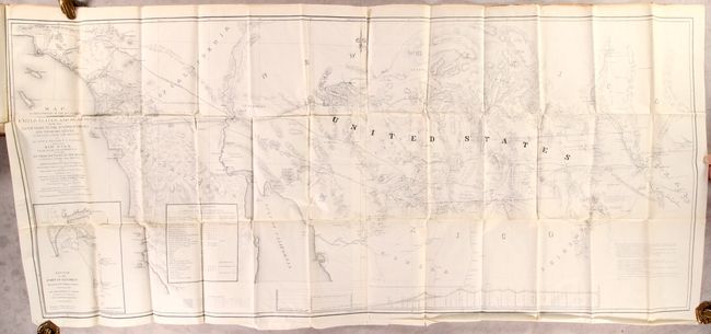
Cornerstone Map of the Gadsden Purchase

"[Map in Report] Map of that Portion of the Boundary Between the United States and Mexico, from the Pacific Coast to the Junction of the Gila and Colorado Rivers ... and the Rio Gila from Near Its Intersection with the Southern Boundary of New Mexico…", Gray, Andrew B.

Subject: Southwestern United States & Mexico

Period: 1855 (published)

Publication: Sen. Ex. Doc. 55, 33rd Congress, 2nd Session

Color: Black & White

Size:
49.4 x 21.5 inches
125.5 x 54.6 cm
Download High Resolution Image
(or just click on image to launch the Zoom viewer)

This map and report are the final documentation of the boundary between the United States and Mexico. This historic and informative map shows the territory acquired under the treaty by Gadsden in 1854. It covers the region between the 30th and 34th parallels and extends from Los Angeles to El Paso. The map also delineates two disputed boundaries, namely "Messrs Bartlett and Counde's Line for Southern Boundary of New Mexico…" and "Boundary of New Mexico marked on the Treaty Map (Disturnell) about 8 miles North of El Paso". Insets of "Sketch of the Port of San Diego, surveyed by U.S. Boundary Commission in 1849 and 1850", "Table of Reference. Latitudes and Longitudes of Principal Points" and "Profile of Country from the Rio Grande to the Gulf of California; and from Rio Grande to the junction of the Gila and Colorado Rivers." A remarkable and very large cornerstone map of this important boundary treaty. Bound with the original 50-page report that also includes That Part of Disturnell's Treaty Map in the Vicinity of the Rio Grand and Southern Boundary of New Mexico (11.2 x 8.8"), which further illustrates the disputed region. Thick octavo. Bound in contemporary full leather with numerous other documents, some with maps, including Fuller’s survey of the Rio Grande.

References: Wheat (TMW) #839 & #840; Wagner-Camp #254; Howes #G-330; Sabin #28376; Streeter #488.

Condition: A

The large folding map is clean and bright on supple paper with the usual short binding tear at left. The small folding map has a binder's cut with loss of border at lower left. Report text is mostly clean and tight. Binding has only minor wear with bumped corners. An overall attractive example.

Estimate: $1,200 - $1,500

Sold for: $700

Closed on 2/10/2021

Archived