Catalog Archive
Auction 181, Lot 190

First Edition

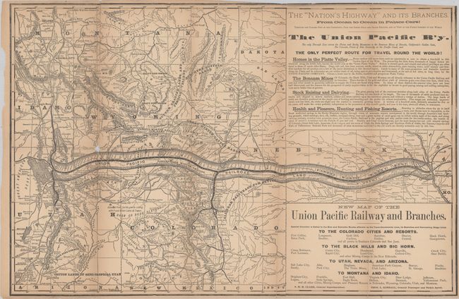
"New Map of the Union Pacific Railway and Branches [in] To the Rockies and Beyond, or a Summer on the Union Pacific Railroad and Branches…",

Subject: Western United States, Railroads

Period: 1878 (published)

Publication:

Color: Black & White

Size:
26 x 17 inches
66 x 43.2 cm
Download High Resolution Image
(or just click on image to launch the Zoom viewer)

This scarce 141-page guide was published by Robert Strahorn and describes much of the west including the "Black Hills, Big Horn and San Juan regions, and special articles on stock raising, farming, mining, lumbering and kindred industries of the trans-Missouri region." The guide features a number of wood engravings within the text as well as the large folding New Map of the Union Pacific Railway and Branches (26 x 17") attached to the rear cover. The map extends from Omaha to the Great Salt Lake along the wide path of Union Pacific Railroad lands, extending north to Montana and the Dakotas and south to the New Mexico/Arizona border. It shows remarkable detail on gold mines, farming prospects, land descriptions, and a large section of text at right promoting the railroad and opportunities in the West. Printed by Omaha Republican Print. First edition. Octavo, gilt stamped soft cloth covers.

References: Howes #S-1058.

Condition: B

Issued folding with light toning and numerous fold separations that have been closed on verso with archival tape. There is a small area of loss at the left fold junction and the map has been trimmed to the border at top right. Text is lightly toned. Ex-library (Library of Congress) with the usual markings. Covers are lightly worn and faded, and the back cover is detached.

Estimate: $300 - $400

Sold for: $275

Closed on 2/10/2021

Archived