Catalog Archive
Auction 181, Lot 157

German Edition of Capt. John Smith's Foundation Map of New England

"New England die Mercklichsten Dheile...", Smith, John (Capt.)

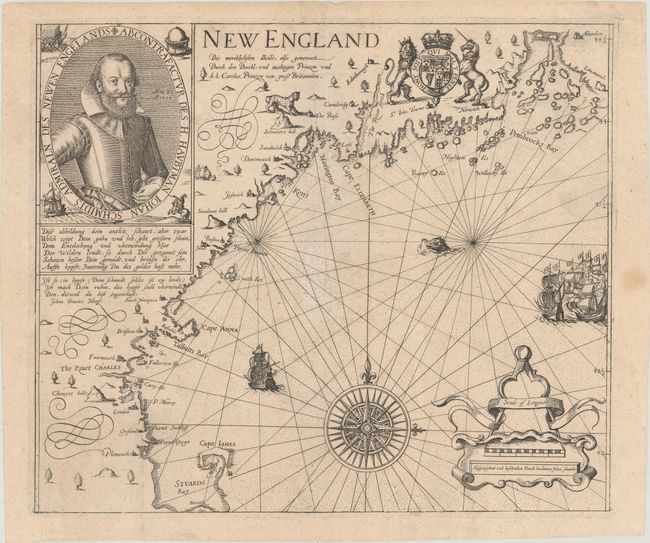
Subject: Colonial New England United States

Period: 1617 (circa)

Publication:

Color: Black & White

Size:
13.6 x 11.5 inches
34.5 x 29.2 cm
Download High Resolution Image
(or just click on image to launch the Zoom viewer)

This is the German edition of John Smith's important foundation map of New England, the first map to name the region and the second to focus on it, after the 1565 Gastaldi/Ramusio map of New France and New England. On March 3, 1614, Captain John Smith, commanding two ships and a crew of 45 men, departed England to return to the New World, this time to the region then known as North Virginia. After six weeks, he arrived at Monhegan Island, just off the coast of present-day Maine. His original mission was to catch whales and mine for copper and gold, but when the whaling proved too difficult, Smith and 8 of his men split from the rest of the crew to explore the coast and trade furs. Smith was bothered by the inaccuracy of previous maps of the region and in only six weeks was able to chart the coast with remarkable accuracy.

Upon returning to England, Smith gathered funding for a return voyage to establish a colony at Plymouth, an area he described as "an excellent good harbour, good lands, and no want of anything but industrious people." But each of Smith's subsequent attempts to return to the region were foiled. On his second attempt in 1615, Smith was captured by a French vessel. To pass the time as he was being held prisoner, he wrote the manuscript of A Description of New England. The following year, the book was published, accompanied by a map of the New England coast engraved by Simon van de Passe, with place names invented by Prince Charles. The work would prove to be very influential. Although Smith was never able to establish his colony in Plymouth, his favorable assessment of the place lead the Mayflower Pilgrims to settle there.

This German edition of the map is based on Smith's first state. It appeared in Levinus Hulsius's Dreyzehente Schiffahrt (1617) as well as his later work Ein und Zwantzigste Schiffahrt (1629). The map covers the coast from Cape Cod Bay (here called Stuards Bay) north to Penobscot Bay (here Pembrocks Bay). Aside from Plimouth and the River Charles, few of Prince Charles' place names stuck. There is some topographical detail, and a large spotted jungle cat lurks in present-day Maine. Sailing ships and a sea monster appear in the ocean, and a compass rose capped with a fleur-de-lis radiates rhumb lines. The map is further decorated by a distance scale cartouche, the Royal Arms, and a portrait of John Smith with an accompanying inscription in German text. This is an unusual and desirable example with full margins.

References: Burden #190; McCorkle #617.1; cf. Deak #19; cf. Fite & Freeman #34; cf. Pritchard & Taliaferro #6.

Condition: A

A crisp impression issued folding, now flat, with minor toning and soiling and a small hole at center that has been expertly repaired on verso.

Estimate: $7,500 - $9,000

Sold for: $6,500

Closed on 2/10/2021

Archived