Catalog Archive
Auction 180, Lot 395

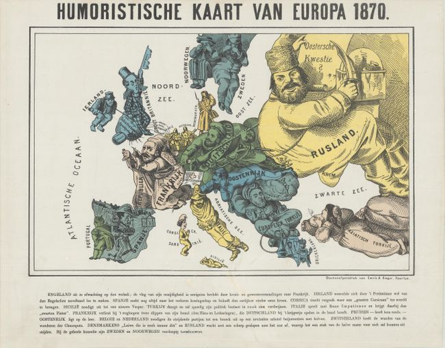
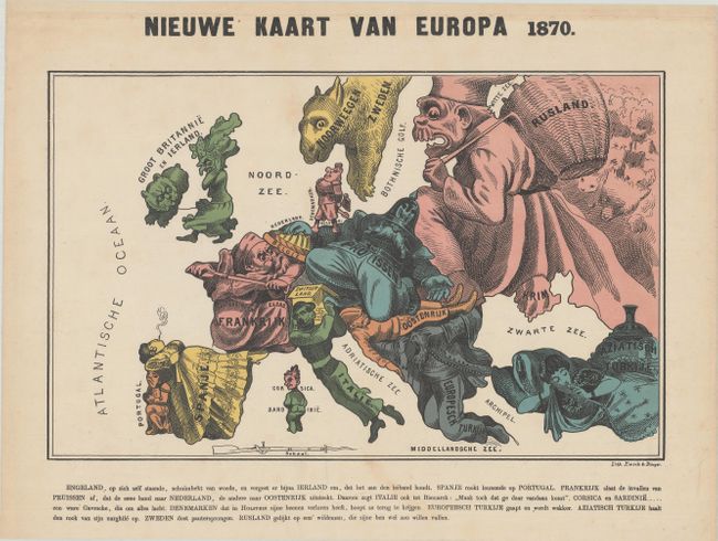
Pair of Satirical Dutch Maps Showing Contrasting Views at the Outset of the Franco-Prussian War

"[Lot of 2] Humoristische Kaart van Europa 1870 [and] Nieuwe Kaart van Europa 1870", Emrik & Binger

Subject: Europe, War

Period: 1870 (published)

Publication:

Color: Printed Color

Size:
See Description
Download High Resolution Image
(or just click on image to launch the Zoom viewer)

These two satirical Dutch maps, both published by Emrik & Binger in The Netherlands, show contrasting views of the Franco-Prussian War in 1870. The first is a copy of Arnold Neumann's map that was first published in German and shows a pro-German view of the conflict. The second is a copy of French illustrator Paul Hadol's map, which is clearly pro-France. These popular maps represent various countries and regions with human and animal caricatures with props to help illustrate the situation. The maps were republished in several different languages and distributed throughout Europe. Dutch text below each map describes each country's "character."

A. Humoristische Kaart van Europa 1870, (15.3 x 9.9"). In this edition Germany is shown as a strong soldier seizing Alsace and Lorraine from France's uniform while France flees in fear. Austria lies in wait while Norway and Sweden view the event from afar through binoculars. The Russian giant uses one hand to sharpen his knife while holding a sheet with "Oriental Question" in his other hand. Neutral England is depicted as a gentleman sitting atop a wool sack, holding the leash to Ireland's peasant. Italy is wrapped up in a struggle with Rome while both European and Asiatic Turkey lounge around smoking. Condition: On a bright sheet with very minor soiling and a couple of archivally repaired tears along the top edge of the sheet. (A)

B. Nieuwe Kaart van Europa 1870, (15.3 x 9.6"). At the center of the conflict are France and Prussia, with France depicted as an old man using his sword to thwart the advances of Prussia. Prussia appears as a stocky Otto von Bismarck with his hat pulled over his eyes and kneeling on Austria, a sleeping soldier, while his right hand completely covers Holland. England is shown as an enraged old woman walking her dog (Ireland) and turning her back on Europe. The Balkans are represented by a man who is yawning and just beginning to awake. A Spanish senorita naps on a kneeling Portugal, while Turkey, in the guise of a harem girl smokes a hookah. The figure of Garibaldi represents Italy, his head and shoulders protected from Prussian encroachment by the shelter of a Swiss roof. Norway and Sweden take the form of a sheep. Russia is depicted as the bogey-man, trying to fill up his basket (with shadowy bear-like figures behind him). Condition: Light soiling and minor toning. (B+)

A remarkable pair of maps that give unique perspectives on the Franco-Prussian War.

References: cf. Tooley (MCC-1) #75 & #80.

Condition:

See description above.

Estimate: $1,500 - $1,800

Sold for: $850

Closed on 11/18/2020

Archived