Catalog Archive
Auction 180, Lot 383

"Carta Esferica de la Parte Sur de la America Meridional. En la Qual se ha Colocado el Estrecho de Magallanes...",

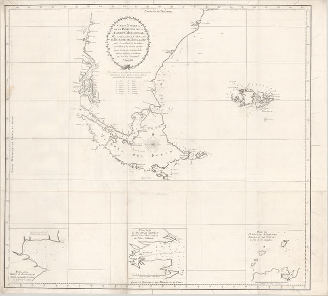
Subject: Southern South America

Period: 1788 (dated)

Publication: Relacion del Ultimo Viage al Estrecho de Magallanes

Color: Black & White

Size:
24.4 x 22.8 inches
62 x 57.9 cm
Download High Resolution Image
(or just click on image to launch the Zoom viewer)

This chart details the southern tip of South America and in particular the Strait of Magellan to illustrate the explorations made by Spanish Captain Antonio de Cordoba in 1785-89. Engraved by Fernando Selma and published in Jose de Vargas y Ponce's Relacion del Ultimo Viage al Estrecho de Magallanes. The waters are filled with navigational information, including depth soundings, rocks, shoals, and a lettered guide to the material found on the sea floor. Three insets depict bays along the Le Maire Strait, Isla de los Estados, and the Falkland Islands (here "Islas Maluinas").

References: Phillips (Atlases) #18189-91; Sabin # 16765.

Condition: B+

Issued folding on a sturdy sheet, now flattened with light offsetting, minor soiling, and archival repairs to a short fold separation at bottom and a tear that enters 1" into image at left. Professionally remargined at left with part of the neatline replaced in facsimile.

Estimate: $475 - $600

Sold for: $350

Closed on 11/18/2020

Archived