Catalog Archive
Auction 180, Lot 303

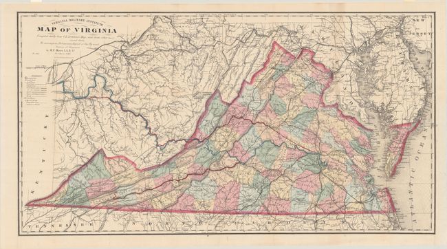
Includes the Third Edition of the Bucholtz-Ludwig Map of 1858 in Fine Condition

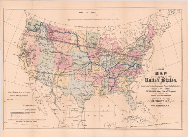
"Virginia Military Institute Map of Virginia [with] Physical Survey of Virginia. Geographical Position of Its Commercial Advantages, and National Importance. (Preliminary Report)", Maury, M. F.

Subject: Virginia, Civil War Reconstruction

Period: 1868 (published)

Publication:

Color: Hand Color

Size:
34.9 x 18.6 inches
88.6 x 47.2 cm
Download High Resolution Image
(or just click on image to launch the Zoom viewer)

This detailed map of the state was issued shortly after the conclusion of the Civil War and, according to Bill Wooldridge's excellent article in the Portolan, is the third edition of the Bucholtz-Ludwig map of 1858. It is the same width as the original Bucholtz map but about 5" shorter, and a new title imprint has replaced the old table of railroads. In 1868 General Francis Smith, Superintendent of the Virginia Military Institute, convinced Maury to return to Virginia (from England) to become a Physics professor and produce a "Physical Survey of Virginia." The survey was intended to aid in Virginia's recovery from the Civil War with the goal of developing "the physical resources of the State, to make known its geography, and to point out the great commercial advantages which naturally arise from its situation with regard to the sea and the interior." While the original goal of both Smith and Maury was to carry out brand new surveys and triangulations, the reality was that Maury was only given 6 months to complete the task. Given the tight timeline, Maury elected to use Ludwig's map with some modifications, and gives credit to Ludwig as the engraver.

Cartographically, the map extends west through the unnamed West Virginia to the Ohio River with Virginia counties highlighted in hand color. A key at left identifies towns, cities, completed railroads, proposed railroads, canals, hot springs, and more. Of particular interest in this example is the erroneous state border that locates Alleghany, Bath and Highland counties in West Virginia that was accidentally held over from Ludwig's earlier map. While Maury corrects this to a degree by coloring these counties to be part of Virginia, the engraved state border is clearly visible on the eastern edge of these counties. Also of interest is the use of color (not defined in the key) to highlight specific railroads and canals of importance including a rail line to the coal riches of southwest Virginia and both a potential railroad and canal extending to the Ohio River. Completing a communication with the Ohio River would have opened up a new trade route between the Mississippi River and Atlantic Ocean, and resulted in tremendous benefit to the state's economy.

Accompanying the large Virginia map are two maps: Map of the United States. Constructed on the Rectangular Tangential Projection and Steam Line Between Norfolk & Flushing Showing the Back Country Geographically Tributary to Each. This first map includes a blue line running along major rivers connecting the Atlantic to the Pacific Ocean and labeled "Route to the Pacific pointed out by the Rev. James Maury in 1753." While it may have seemed plausible in 1753, it could not be refuted until Lewis & Clark traversed the area 50 years later (Reverend Maury was Matthew Fontaine Maury's grandfather). The map also includes an line of equidistance between Norfolk and New York extending to the Pacific - another visual effect to encourage trade to flow through Virginia's canals and railroads. Includes the 90 page disbound report.

Matthew Fontaine Maury (1806-73) was Superintendent of the U.S. Naval Observatory from 1842-1861. In 1855 he published his Physical Geography of the Sea, which was the first comprehensive book on oceanography. Prior to his role at VMI (1868-73), Maury was a Commander in the Confederate Navy.

List of maps:

A. Virginia Military Institute Map of Virginia Compiled Chiefly from C.L. Ludwig's Map, and from Other More Recent Data, hand color (34.9 x 18.6"). Condition: A fine example, issued folding and now flattened and backed with tissue. (A+)

B. Map of the United States. Constructed on the Rectangular Tangential Projection, by J.H. Waddell, hand color (26.3 x 17.9"). Condition: Issued folding with a 3.5" edge tear at left and numerous fold separations that have been mostly closed on verso with archival tape. (B)

C. Steam Line Between Norfolk & Flushing Showing the Back Country Geographically Tributary to Each..., black & white (44.8 x 8.2"). Condition: Issued folding with minor toning, scattered foxing, and several extraneous creases adjacent to the folds. (B)

References: Wooldridge (Portolan - Spring 2007) pp. 26-39; Stephenson & McKee, p. 268; Phillips (Maps) p. 990.

Condition:

See description above for condition of maps. Report text is lightly toned and the paper wrappers are worn and detached. (Report: B)

Estimate: $1,400 - $1,700

Sold for: $1,000

Closed on 11/18/2020

Archived