Catalog Archive
Auction 180, Lot 271

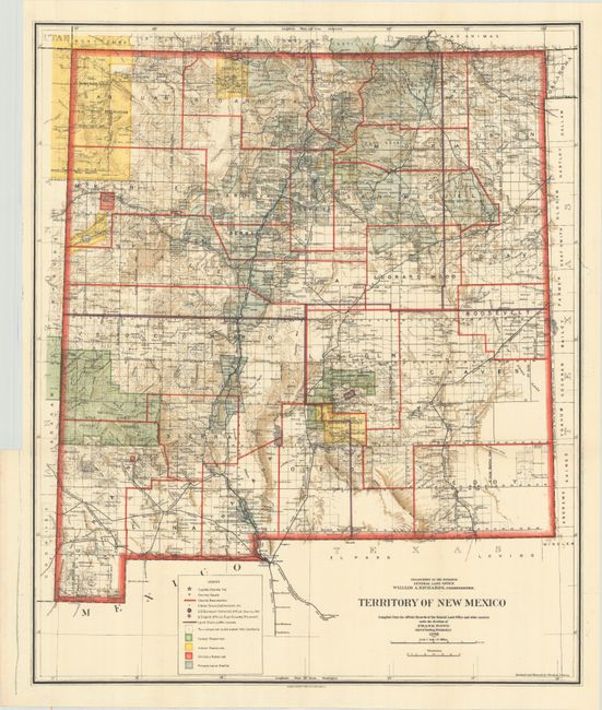
"[Map with Report] Territory of New Mexico [with] Report of the Governor of New Mexico", U.S. Government

Subject: New Mexico

Period: 1903 (dated)

Publication: H.R. Doc. 5, 58th Congress, 2nd Session

Color: Printed Color

Size:
18.1 x 21.8 inches
46 x 55.4 cm
Download High Resolution Image
(or just click on image to launch the Zoom viewer)

This colorful and fascinating map with great detail was published only nine years before New Mexico obtained statehood. The extent of existing Indian reservations, Military reservations, Forest Reserves and Private Land Grants is shown through color and hash. Townships containing coal or probably containing coal are also colored, combining to provide great visual impact. The map is filled with information on watershed, mountains, railroads, wagon roads, unsurveyed townships, etc. In 1903, Guadalupe county was renamed Leonard Wood and then returned to Guadalupe in 1905. This is the only map we are aware of that shows the short-lived county of Leonard Wood. The map was compiled by Frank Bond, Chief of Drafting Division.

The map is accompanied by the 674 page Report of the Governor of New Mexico which was issued as part of the Annual Reports of the Department of the Interior. The comprehensive report includes the physical characteristics of the state, descriptions of its cities and counties, climate, geology, agriculture, and more. Features many full-page photographic plates including a frontispiece of the Capitol building in Santa Fe. Octavo, hardbound in full contemporary leather with gilt title labels on spine.

References:

Condition: A

Condition code is for the folding map which is clean, bright, and near fine. Plates are fine and text is very good with light toning. The hinges are starting and the binding is worn and scuffed.

Estimate: $180 - $220

Sold for: $130

Closed on 11/18/2020

Archived