Catalog Archive
Auction 180, Lot 16

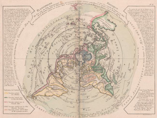
"Planisphere Physique ou l'on voit du Pole Septentrional ce que l'on Connoit de Terres et de Mers...", Buache/Dezauche

Subject: World

Period: 1780 (circa)

Publication:

Color: Hand Color

Size:
17.3 x 13.4 inches
43.9 x 34 cm
Download High Resolution Image
(or just click on image to launch the Zoom viewer)

This uncommon and unusual thematic map is presented on a North Polar projection and depicts the tracks of several important explorers including Tasman, Halley and Magellan. The color-coding identifies which landmasses drain into the various bodies of water around the world. Inland detail is confined to rivers and major mountain ranges depicted with strong hachuring. In North America there is a large Sea of the West and a nearly complete Northwest Passage. Australia is still shown with a conjectural coastline, making it considerably too wide. The continent connects to both New Guinea and Terre du St. Esprit (the Land of the Holy Ghost), discovered by Queiroz. Engraved by Desbruslins.

References: McGuirk #60; Phillips (Maps) p. 1091; Potter pp.178-9 (illus).

Condition: B+

On a watermarked sheet with faint toning along the centerfold and a few spots of foxing. There is a light dampstain along the bottom sheet edge, far from the map image.

Estimate: $275 - $350

Sold for: $325

Closed on 11/18/2020

Archived