Catalog Archive
Auction 179, Lot 181

Early Revolutionary War Chart of the Delaware Bay

"A Chart of Delaware Bay and River, Containing a Full and Exact Description of the Shores, Creeks, Harbours, Soundings, Shoals, Sands and Bearings of the Most Considerable Land Marks...", Dury, Andrew

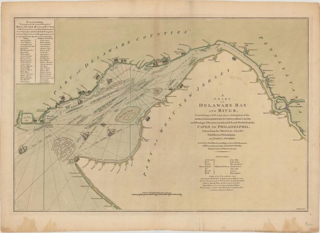
Subject: Colonial Delaware Bay

Period: 1776 (dated)

Publication:

Color: Hand Color

Size:
27.3 x 18 inches
69.3 x 45.7 cm
Download High Resolution Image
(or just click on image to launch the Zoom viewer)

This important Revolutionary War period chart was issued in November of 1776. It is an early English derivative of Joshua Fisher's important plan of the Delaware Bay and river that was published in 1775 to assist pilots in bringing ships into Philadelphia. The chart shows good detail of channels, soundings, shoals and flats, anchorages, and several property owners along the banks of the bay. A list of pilots and masters who believe the chart would help "safe navigation" in the bay is located at upper left along with a tide table at lower right. Decorated by five ships sailing in the bay - an addition made by Dury.

References: Sellers & Van Ee #1359.

Condition: B+

Issued on sturdy watermarked paper with a hint of toning along the upper centerfold, a few faint spots in the image, and a vertical extraneous crease to the right of the centerfold. A couple of dampstains are confined to the bottom blank margin.

Estimate: $2,500 - $3,250

Sold for: $1,500

Closed on 9/16/2020

Archived