Catalog Archive
Auction 178, Lot 74

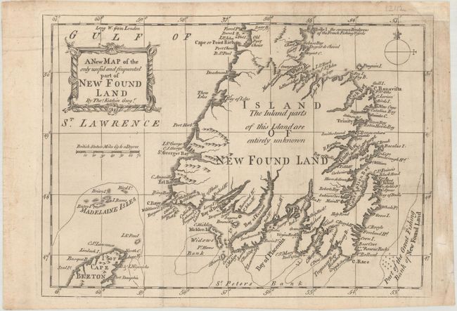
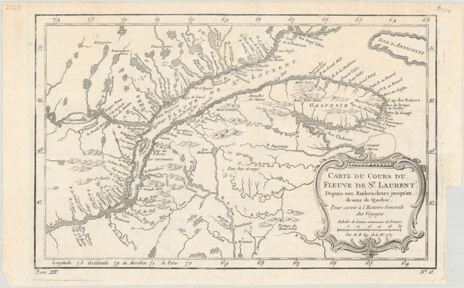
"[Lot of 2] A New Map of the Only Useful and Frequented Part of New Found Land [and] Carte du Cours du Fleuve de St. Laurent Depuis son Embouchure Jusqu'au Dessus de Quebec...",

Subject: Eastern Canada

Period: 1757-62 (circa)

Publication:

Color: Black & White

Size:
See Description
Download High Resolution Image
(or just click on image to launch the Zoom viewer)

A. A New Map of the Only Useful and Frequented Part of New Found Land, by Thomas Kitchin, circa 1762 (9.7 x 7.0"). Most of the detail on this uncommon chart of Newfoundland is concentrated along the coast. The map depicts the southern 90% of the island up to Cape Rich. It locates Widows Bank, the Great Fishing Bank, Madelaine Isles (Magdalen Islands), and much more. Interior areas "are entirely unknown." A portrait-style title cartouche and simple compass rose adorn the map. This map originally appeared in London Magazine. Reference: cf. Jolly #LOND-215. Condition: Issued folding, now flat, on watermarked paper with light soiling and two horizontal printer's creases at top that have been reinforced with archival materials on verso. (B+)

B. Carte du Cours du Fleuve de St. Laurent Depuis son Embouchure Jusqu'au Dessus de Quebec. Pour Servir a l'Histoire Generale des Voyages, by Jacques Nicolas Bellin, from Prevost's Histoire Generale des Voyages, dated 1757 (11.9 x 7.6"). Nice example of the first state of this copper engraved map, published by Prevost. The map details the course of the St. Lawrence River from Anticosti Island and the mouth west to beyond Quebec. It details many rocks and shoals in the river with numerous villages and forts located along the shore. Decorated with a rococo-style cartouche that includes a distance scale. Reference: Kershaw #626. Condition: Issued folding on watermarked paper with a few small areas of paper weakness. (A)

References:

Condition:

See description above.

Estimate: $240 - $300

Sold for: $160

Closed on 6/10/2020

Archived