Catalog Archive
Auction 178, Lot 295

Earliest Printed Map of Cambridge

"Cantebrigia, Opulentissimi Anglie Regni, Urbs Celeberrimi Nominis, ab Academie Conditore Cantabro...", Braun & Hogenberg

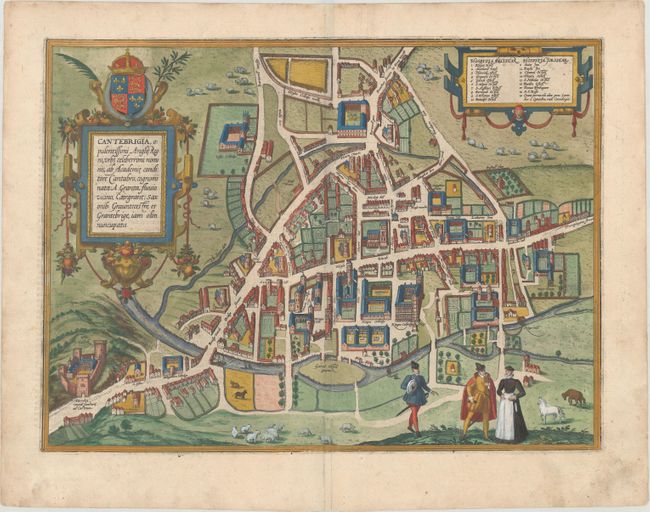
Subject: Cambridge, England

Period: 1590 (circa)

Publication: Civitates Orbis Terrarum, Vol. II

Color: Hand Color

Size:
17.5 x 12.9 inches
44.5 x 32.8 cm
Download High Resolution Image
(or just click on image to launch the Zoom viewer)

Braun & Hogenberg's Civitates Orbis Terrarum or "Cities of the World" was published between 1572 and 1617. Within the six volumes, 531 towns and cities were depicted on 363 plates, providing the reader with the pleasures of travel without the attendant discomforts. Braun wrote in the preface to the third book, "What could be more pleasant than, in one's own home far from all danger, to gaze in these books at the universal form of the earth . . . adorned with the splendor of cities and fortresses and, by looking at pictures and reading the texts accompanying them, to acquire knowledge which could scarcely be had but by long and difficult journeys?" Braun and Hogenberg incorporated an astonishing wealth of information into each scene beyond the city layout and important buildings. The plates provide an impression of the economy and prominent occupations, and illustrate local costumes, manners and customs.

This is the earliest printed map of Cambridge, showing a bird's-eye plan of the city. Braun described the colleges of Cambridge as "built with such grandeur and magnificence that you might think they were royal palaces and not accommodation for students." The plan provides an excellent view of these colleges and the beautiful surrounding countryside. A key at top identifies 19 locations including Peterhouse, King's College, Jesus College, Christ College, Magdalen College, and the castle that was built by the Normans in 1068. The Latin title is sometimes confused with Canterbury because Cambridge was originally known as Grentabrige or Cantebrigge (Grantbridge), and the river that flowed through it was called the Granta. Over time the name of the town changed to Cambridge and the river became known as the River Cam. This plan is based on a drawing by William Smith. German text on verso.

References: Fussel, p. 150.

Condition: A

A nice impression on a watermarked sheet with marginal soiling and a few small worm holes in the blank margins.

Estimate: $950 - $1,200

Sold for: $900

Closed on 6/10/2020

Archived