Catalog Archive
Auction 177, Lot 634

Blaeu's Map of China Featuring Fictitious Lakes and Rivers in Full Contemporary Color

"China Veteribus Sinarum Regio nunc Incolis Tame Dicta", Blaeu, (Family)

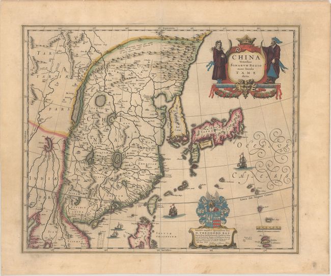
Subject: China, Korea & Japan

Period: 1635 (published)

Publication: Novus Atlas

Color: Hand Color

Size:
19.5 x 16.1 inches
49.5 x 40.9 cm
Download High Resolution Image
(or just click on image to launch the Zoom viewer)

Several large lakes dominate the topography of this elegantly engraved map of China. The Great Wall forms the northern boundary of China. The fictitious Chiamay Lacus is shown with numerous rivers flowing south into India and Siam. Korea is depicted as a strangely shaped island separated from the mainland by a narrow strait. Taiwan is located in a roughly correct position, named as both Pakan al I. Formosaand Tayoan The three main islands of Japan are shown on the Ortelius/Teixeira model. A fine title cartouche is flanked by a Chinese woman and man. The map is further adorned with a coat of arms (dedicated to Theodore Bas, a director of the Dutch East India Company), European ships, and Chinese sampans. German text on verso.

References: Van der Krogt (Vol. II) #8410:2A.2:32.

Condition: B+

Excellent impression with full contemporary color. There is an archivally repaired centerfold separation at bottom that enters about 3" into image, a minor crease in image at bottom, and light printer's ink residue. There is marginal soiling and a short edge tear in the top blank margin that has been closed with archival materials on verso.

Estimate: $1,600 - $1,900

Sold for: $900

Closed on 4/29/2020

Archived