Rare Anthropological Map of the World by Female Cartographer
"Esquisse d'un Tableau General du Genre Humain. Ou l'on Appercoit d'un Seul Coup d'Oeil les Religions et les Moeurs des Differents Peuples...", Moithey, Maurille Antoine
Subject: World
Period: 1787 (circa)
Publication:
Color: Hand Color
Size:
26.3 x 19.4 inches
66.8 x 49.3 cm
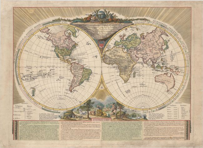
This anthropological map identifies the religions, races, manners, and physical traits of people around the world. While the races were meant to be color-coded to the map, the religions, customs and physical traits are identified by symbols, with individual regions and even islands marked with up to seven symbols each. The four noted religions are Catholic, Christians who are separated from the church, Muslim, and Idolaters. The races are listed as white, black, bronze, olive, tan and yellow. The manners are educated, living in a society, savage, polygamist, nudist, humane, and cruel. The physical traits are described as small, medium, large, very large, well formed, malformed, handsome, and ugly. Below the map, the author describes the types of people found around the world and explains that there are occasionally migrations of people that cause their characteristics to change. The author also notes that although one might claim that Judaism is missing from the map, the religion was purposely excluded as they are a people who "wander all over the world, without altars, without sacrifices, and without a leader."
Geographically, the map is a bit simpler to accommodate the space needed for the symbols, but still has interesting cartographic inaccuracies. Notably, in North America is a large Mer de l'Ouest (Sea of the West) as well as the conjectural Lac de Fuentes and Lac de Velasco. Various Native Indian tribes are identified, most of which are noted as savages and/or cruel. In the Eastern Hemisphere, Australia is connected to Tasmania, New Guinea is only partially delineated, and Hokkaido (Jesso) appears nearly attached to mainland Asia. The hemispheres are surrounded by rings identifying the climactic zones and the lower cusp is filled with a lovely vignette of Paradise with Adam and Eve in the Garden of Eden.
The map was created by Marie Le Masson le Golft and published by Maurille Antoine Moithey. Marie Le Masson le Golft was a French naturalist, scientist and academician. She is best known for her work Balance de la Nature, in which she evaluated hundreds of animals, plants and minerals and assigned grades to each based on God's "harmonious design."
References: McGuirk #196.
Condition: B+
A crisp impression on watermarked paper with light soiling and some tiny worm holes and tracks in the image that are only visible when held to light. There are professional repairs to several large chips along the edges of the sheet, with a portion of the image replaced in facsimile at top left and a minor amount of neatline replaced at bottom right. The map was colored later, so the color-coding by race is no longer apparent.