Catalog Archive
Auction 176, Lot 47

"Atlantis Insula, a Nicolao Sanson Antiquitati Restituta; nunc Demum Majori Forma Delineata, et in Decem Regna, Iuxta Decem Neptuni Filios Distributa...", Sanson, Guillaume

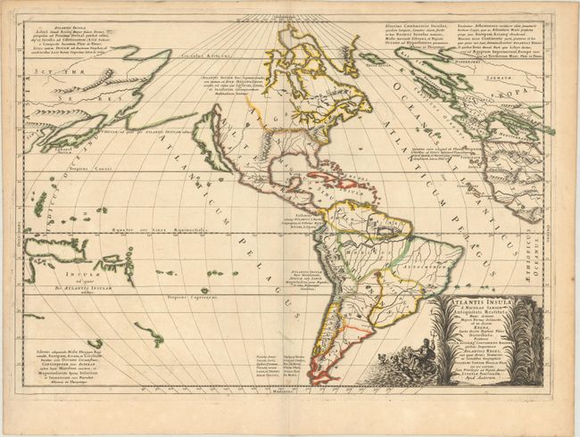
Subject: Western Hemisphere - America

Period: 1669 (dated)

Publication: Cartes Generales de Toutes les Parties du Monde…

Color: Hand Color

Size:
22 x 15.6 inches
55.9 x 39.6 cm
Download High Resolution Image
(or just click on image to launch the Zoom viewer)

This is Sanson's unusual composition showing ancient geography within a contemporary outline of the Americas, which is noted in the cartouche as the mythical island of Atlantis. This is a purely topographical map and the only cities shown are Mexico City and Cuzco, the capitals of the New World. The continents are divided into ten regions, named for the ten sons of Neptune. The Great Lakes are shown but still very misshapen. A large lake in the western part of North America is the source of a river that empties into the sea between the continent and the island of California. In South America, the mythical Lake Parime appears just north of the equator, but is not named. The map includes both Asian and European coastlines and bits of New Guinea, New Zealand, and Australia. This is the second state as indicated by Burden, dated 1669, but published circa 1677, with "Apud Autorem" replacing Mariette's credit.

References: Burden #405; McLaughlin #46; cf. Pastoureau, SANSON V D [208]; cf. Tooley p. 124, #51.

Condition: A

A sharp impression on watermarked paper with a few negligible spots and marginal toning.

Estimate: $600 - $750

Sold for: $350

Closed on 2/12/2020

Archived