Catalog Archive
Auction 175, Lot 4

First Printed World Map to Depict Western Australia

"Nova Totius Terrarum Orbis Geographica ac Hydrographica Tabula", Keulen, Johannes van
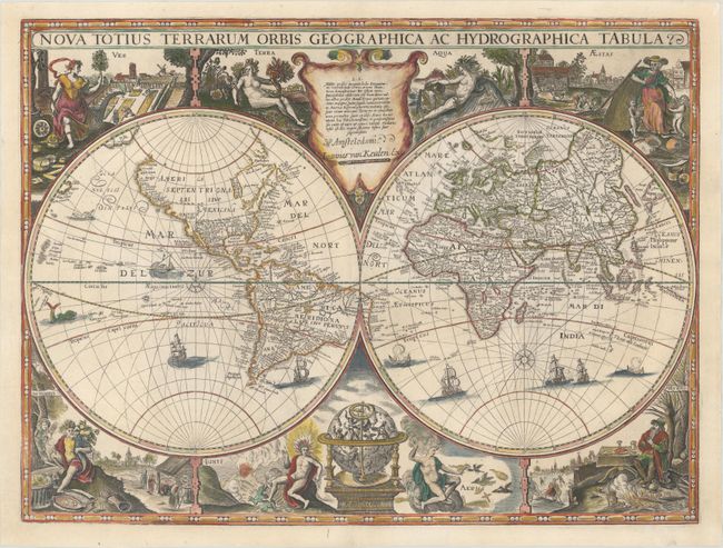
Subject: World

Period: 1680 (circa)

Publication: Le Grand Nouvel Atlas de la Mer...

Color: Hand Color

Size:
21.6 x 16.2 inches
54.9 x 41.1 cm
Download High Resolution Image
(or just click on image to launch the Zoom viewer)

This map, which was first published by Jodocus Hondius circa 1625, was the first printed world map to include the Dutch discoveries on the western coast of Australia. Several short portions of coastline have been added along with five place names: Iacop Remmer Rivier, Dirck Hartogs ree, F Hontmans acbroo[?]levs, Dedelis landt, and T. Lant van Eendracht. These place names correspond with Hessel Gerritsz' 1622 manuscript map of the Indian Ocean. Another key change on this map is the elimination of the great Southern Continent, replaced with a number of sailing ships. North America is not nearly as wide as is commonly found on early 17th century maps, and California is shown as a peninsula. There are a number of early place names in North America, including Quivira Regn, Florida and Anian, in addition to a number of fictitious names. South America still includes the two mythical lakes: an unnamed Lake Parime with the golden city of Manoa on its northern shore in Guyana, and Lacus Epana in Brazil. Geographical inaccuracies continue in Asia, with Korea depicted as an island, spurious lakes and rivers in China and Southeast Asia, rudimentary outlines of the islands in the East Indies, and only the northern coast of New Guinea.

Surrounding the hemispheres are allegorical figures representing the four elements and the four seasons, as well as a celestial globe, which includes the engraver's imprint. An unusual and decorative feature of this map are the curved lines radiating from the compass roses, which some believe are isolines, or the lines of magnetic declination, and would signify an early depiction of this concept.

This is the fourth state (of six) of this map, with Van Keulen's signature replacing that of Clement de Jonghe (which previously replaced Jodocus Hondius) but retaining the original engraver's imprint of Francis van der Hoeye. This map is very rare.

References: Shirley #502.

Condition: A

An excellent impression on a thick, bright sheet with two minute worm holes and a crease adjacent to the centerfold that has been pressed flat.

Estimate: $7,500 - $9,000

Sold for: $21,000

Closed on 11/13/2019

Archived