Catalog Archive
Auction 174, Lot 254

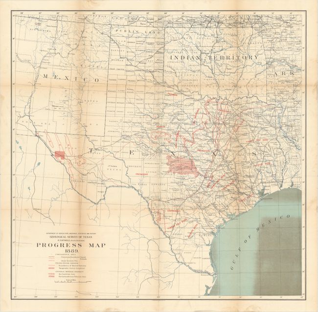
"Geological Survey of Texas ... Progress Map [in] First Annual Report of the Geological Survey of Texas, 1889",

Subject: Texas

Period: 1889 (published)

Publication:

Color: Printed Color

Size:
23.1 x 22.7 inches
58.7 x 57.7 cm
Download High Resolution Image
(or just click on image to launch the Zoom viewer)

While the title states "first annual report," this is actually the third geological survey conducted in the state of Texas by E.T. Dumble. The first survey, the Geological and Agricultural Survey of Texas, was conduced from 1858-67 and the second ran from 1870-73. Both were abruptly discontinued due to political reasons. The present example represented the first work of the newly named Geological and Mineralogical Survey and lasted for eleven years (later resumed by the University of Texas). Its primary purpose was to "search for ores, minerals, oils, coals, clays, and other materials possessing a commercial value." Included in the report are the following papers: the Gulf Tertiary of Texas; Cretaceous Rocks of Texas; Southern Border of the Central Coal Field; The Permian of Texas and its Overlying Beds; Coal Fields of the Colorado River; Geology of Trans-Pecos Texas; and a Preliminary Report on the Central Mineral Region of Texas. At the rear of the volume is a folding map of the state and surrounding region that shows the various mineral districts, coal fields and measures, various beds, and the extent of the surveying. 410 pages with 10 additional illustrations including a folding plate of sections. Quarto, printed paper wrappers.

References:

Condition: B+

Condition code is for the folding map, which is very good with some light discoloration in the Gulf of Mexico at lower right. Text is also very good with some minor toning along the sheet edges. The text is disbound and separated into 7-8 signatures. Paper wrappers are detached and heavily worn and chipped.

Estimate: $170 - $200

Sold for: $120

Closed on 9/11/2019

Archived