Catalog Archive
Auction 174, Lot 206

NO RESERVE

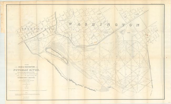
"Chart of the Head of Navigation of the Potomac River. Surveyed by Order of the Sec. of War for the Corporation of Georgetown D.C....", U.S. War Department

Subject: Washington, D.C.

Period: 1857 (dated)

Publication: Sen. Ex. Doc. 34, 35th Congress, 1st Session

Color: Black & White

Size:
40.4 x 24.8 inches
102.6 x 63 cm
Download High Resolution Image
(or just click on image to launch the Zoom viewer)

his uncommon map shows a portion of Georgetown and Washington D.C. along the Potomac River, and includes part of the Chesapeake and Ohio Canal as well as Rock Creek and the Basin. Names the major streets and shows the location of the Washington Monument. Within the Potomac River are hundreds of soundings with notes on the bottom material. Place names mentioned include Alexandria Road, the Alexandria Canal, Mason's Island and Timber Creek. Made under the direction of Capt. L. C. Woodruff by R.W. Burgess of the Topographical Engineers. Engraved by Denis Callahan and printed by the esteemed firm of Julius Bien. A seldomly seen issue that should not be confused with the smaller reprint issued in 1891.

References:

Condition: B+

Issued folding with light toning, scattered foxing, and a number of tiny splits at fold intersections.

Estimate: $180 - $220

Unsold

Closed on 9/11/2019

Archived