Catalog Archive
Auction 173, Lot 302

"Ober Baden", Munster, Sebastian

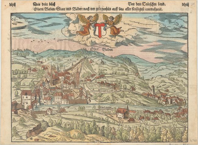
Subject: Baden, Switzerland

Period: 1592 (circa)

Publication: Cosmographey oder Beschreibung Aller Laender…

Color: Hand Color

Size:
13.8 x 10.2 inches
35.1 x 25.9 cm
Download High Resolution Image
(or just click on image to launch the Zoom viewer)

Sebastian Munster (1489 - 1552) was one of the three most renowned cartographers of the sixteenth century, along with Mercator and Ortelius. Munster's Geographia and Cosmographia Universalis were two of the most widely read and influential books of the period. His editions of Ptolemy's Geographia, published between 1540 and 1552, were illustrated with 48 woodcut maps, the standard 27 Ptolemaic maps supplemented by 21 new maps. These new maps included a separate map of each of the known continents and marked the development of regional cartography in Central Europe. The antique geography was a prelude to Munster's major work, the Cosmographia, which was published in nearly 30 editions in six languages between 1544 and 1578 and then was revised and reissued by Sebastian Petri from 1588 to 1628. The Cosmographia was a geographical as well as historical and ethnographic description of the world. It contained the maps from the Geographia plus additional regional maps and city views with nearly 500 illustrations which made it one of the most popular pictorial encyclopedias of the sixteen century.

This dramatic woodcut map of Baden is drawn from a bird's-eye perspective. A pair of angels support the crest of the town above the map. Many farms and houses are located in the surrounding countryside. German text on verso, published in either the 1592 or 1598 edition of Cosmographey oder Beschreibung Aller Laender…

References: cf. Shirley (BL Atlases) T.MUN-1a.

Condition: B+

There are light damp stains along the sheet's edges, one of which enters into map image at bottom, and a couple spots of soiling.

Estimate: $140 - $170

Sold for: $100

Closed on 6/5/2019

Archived