Catalog Archive
Auction 173, Lot 146

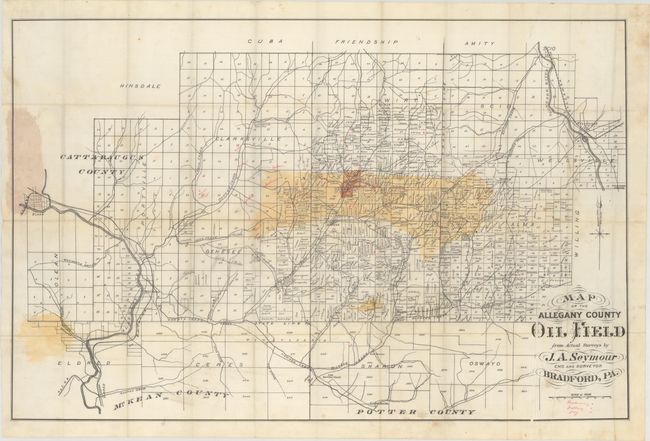
Location of the First Oil Discovery in North America

"Map of the Allegany County Oil Field from Actual Surveys...",

Subject: Western New York, Oil

Period: 1880 (circa)

Publication:

Color: Printed Color

Size:
38.9 x 25.3 inches
98.8 x 64.3 cm
Download High Resolution Image
(or just click on image to launch the Zoom viewer)

This oil map of Allegany County was published by J.A. Seymour of Bradford, Pennsylvania. It presents a detailed view of land ownership that is concentrated in the central and southern portion of the county and is hand colored to show the oil fields. Additional manuscript notations in both pencil and ink indicate producing, drilling and dry wells. Folds into brown cloth covers with gilt title on the front cover. No auction records or dealer listings found. OCLC locates one copy of this map at Stanford.

Surprising to this cataloger, the first recorded discovery of oil in North America was made in Allegany County in 1627. An oil boom in 1881 led to peak production of over 6 million barrels in the county and was the impetus for this map. Even today (as of 2016) Allegany County still has over 1200 active oil wells. For a brief history of oil exploration and production in Allegany County, click here.

References:

Condition: B+

Issued folding with some staining at left where the map was glued to the rear board. Numerous pencil and ink notations have been added to provide additional information to the reader. Map is loose from the boards, which are very good with only minor wear.

Estimate: $250 - $325

Sold for: $150

Closed on 6/5/2019

Archived