Catalog Archive
Auction 172, Lot 65

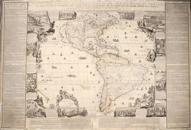
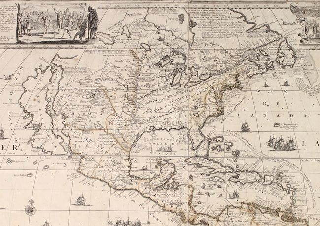
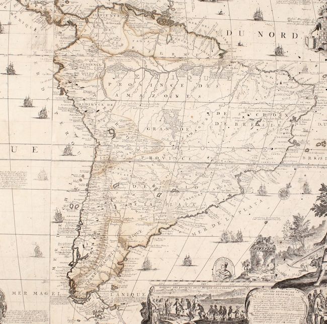
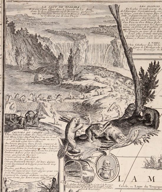
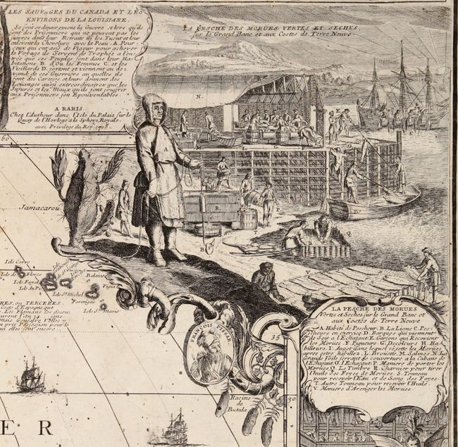
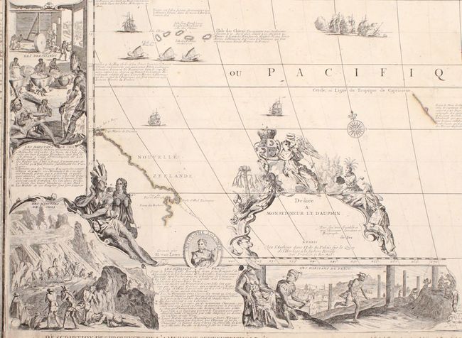
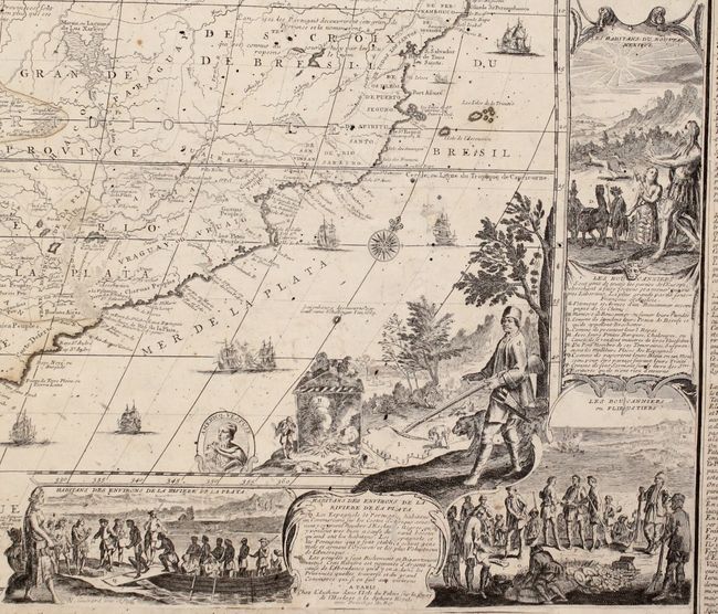
De Fer's Monumental Wall Map of the Americas and the "Original Beaver Map"

"L'Amerique, Divisee Selon Letendue des ses Principales Parties, et dont les Points Principaux sont Placez sur les Observations de Messieurs de l'Academie Royale des Sciences...", Fer, Nicolas de

Subject: Western Hemisphere - America

Period: 1705 (dated)

Publication:

Color: Hand Color

Size:
46.6 x 35.9 inches
118.4 x 91.2 cm
Download High Resolution Image
(or just click on image to launch the Zoom viewer)

This is de Fer's monumental wall map of America, which was the first map to introduce the iconic vignettes of beavers in Canada and a cod fishery in Newfoundland, both of which were subsequently copied by other cartographers, including Herman Moll and Henry Abraham Chatelain. De Fer created this map based on independent sources, primarily from the Academie Royale des Sciences, which regularly received updated maps of New France in the Americas, including those by Jean Baptiste-Louis Franquelin of Montreal. As a result this map portrays a more accurate position of Hudson Bay in relation to the Great Lakes than on other maps of the time period. Much of the cartography, however, is based on inaccurate reports. The map still features the Island of California covering the entire west coast north of the Tropic of Cancer, with an indented northern coastline after Sanson. The unexplored Pacific Northwest is obscured by a vignette of Native American Indians. The mouth of the Mississippi River is located too far to the west - nearly as far west as the Rio Grande, and the Missouri River is named Outantes R. The British colonies are confined to the East Coast and Florida extends north into present-day western Virginia and as far west as present-day Texas. One of the prominent features in northern Mexico is Les Mine de St. Jean et de Ste. Barbe, the legendary Santa Barbara mines of the Chihuahua-Durango region. In South America a large Marais ou Lagunes de los Xarajes appears in the center of the continent. A partial coastline of New Zealand appears at bottom left. The map is richly decorated with cartouches, sailing galleons, vignettes of the New World, and six medallions of famous explorers and rulers, including Magellan, Columbus, Vespucci, Pizarro, Montezuma, and Artha Balipa. Engraved by Hendrick van Loon and Nicolas Guerard.

This four-sheet map was separately published in 1698 and was reissued several times with minor changes, primarily to the imprints. This is the third state of the map with the date updated to 1705 on three of the sheets and erased on the bottom right sheet. The cartouche at bottom left includes a dedication to the Dauphin, the son of Louis XIV, which was added in the second state and later removed after his death in 1711. The panels of French text surrounding the map were printed separately and added to the map, with the imprint at bottom right dated 1713. The text describes the geography and the provinces of North and South America. Measures 62.8 x 43.0" with French text.

References: Burden #744; Dahl (Map Collector #29) pp. 22-26; McLaughlin #165; Tooley (MCC-8) #70.

Condition: B

A nice impression with old, faded outline color, light soiling, scattered foxing, and some small abrasions. The map is backed in archival tissue to repair a number of chips and tears along the edges of the sheet, with some loss of text at bottom and a minor amount of the neatline at top replaced in facsimile. About 3" of the joint at bottom center has come loose, and several of the panels of text are loose along the edges in a few spots. Overall a nice example of this rare map.

Estimate: $20,000 - $25,000

Sold for: $13,500

Closed on 4/17/2019

Archived