Catalog Archive
Auction 172, Lot 63

Uncommon Map Featuring Two Figurative Title Cartouches

"America Septentrionalis. Novissima / America Meridionalis. Accuratissima", Schenk, Pierre

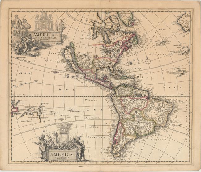
Subject: Western Hemisphere - America

Period: 1695 (circa)

Publication:

Color: Hand Color

Size:
22.1 x 18.8 inches
56.1 x 47.8 cm
Download High Resolution Image
(or just click on image to launch the Zoom viewer)

This is a very handsome, uncommon map of the Americas with two large figurative title cartouches representing each of the continents. The cartography of North America is based on the Sanson-Jaillot model with California as an island and the R. del Norte (Rio Grande) flowing westward from a large inland lake located just north of Taos. Buttons Bay and the Great Lakes are both left open-ended in the west, allowing the possibility of a Northwest Passage. In South America the mythical Parime Lacus straddles the equator, the Amazon River is shown as an elaborate network of waterways, and the Paraguay River has it headwaters in the spurious Xarayes Lake. Quiri Regio and Insule Salmonis are prominently featured in the Pacific.

References: McLaughlin #120; Tooley (Amer) p. 125 #56.

Condition: B+

A dark impression with contemporary color and two small cracks due to the oxidation of the green pigment. There is a bit of scattered foxing along the centerfold at bottom, and short centerfold separations at top and bottom that have been closed on verso with archival material. Remnants of hinge tape on verso.

Estimate: $1,600 - $1,900

Unsold

Closed on 4/17/2019

Archived