Catalog Archive
Auction 172, Lot 24

"Planiglobii Terrestris cum Utroq Hemisphaerio Caelesti Generalis Repraesentatio...", Homann, Johann Baptist
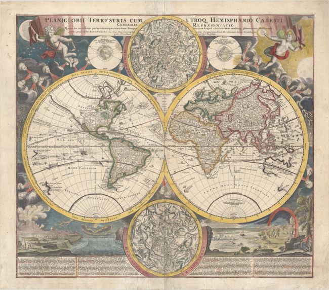
Subject: World

Period: 1744 (published)

Publication:

Color: Hand Color

Size:
21.2 x 18.8 inches
53.8 x 47.8 cm
Download High Resolution Image
(or just click on image to launch the Zoom viewer)

This is one of the most decorative eighteenth century world maps. The two hemispheres are surrounded by vivid engravings of natural phenomena such as a rainbow, earthquakes, and a volcano. Wind heads occupy the starry heavens, and two putti hold the title banner aloft. The map itself shows a typical geographical view of the period. An indistinct Terra Esonis appears above California, here depicted as a peninsula. The partial coastlines of Australia, New Zealand, and New Guinea are noted. Australia is shown to be separate from New Guinea, Carpentaria and Van Diemen's Land. Nova Britannia is shown as a separate island off the coast of New Guinea with the notation that it was discovered by Dampier in 1700. Several explorer's tracks are traced, including Magellan, Dampier, Tasman, Gaetani and Charmont. Nestled between the hemispheres are two detailed celestial maps. Text panels at bottom describe the natural phenomena. A key in the lower margin explains the color coding, which divides the world into various religious sects. Homann borrowed both the cartography and depictions of natural phenomenon from Zurner's similar map circa 1700.

References:

Condition: B+

A nice example with very light soiling. There are faint damp stains along the bottom of the sheet, resulting in a number of short tears in the bottom blank margin, several of which enter between 0.25" and 1.5" into the image, and all of which have been archivally repaired. A small chip that enters 0.25" into the image at bottom center has been professionally repaired with the image replaced in facsimile.

Estimate: $1,200 - $1,500

Sold for: $800

Closed on 4/17/2019

Archived