Catalog Archive
Auction 172, Lot 242

An Important Battle Plan of the American Revolution

"Plan de la Bataille de Montmouth ou le Gl. Washington Commandait l'Armee Americaine et le Gl. Clinton l'Armee Anglaise, le 28 Juin 1778",

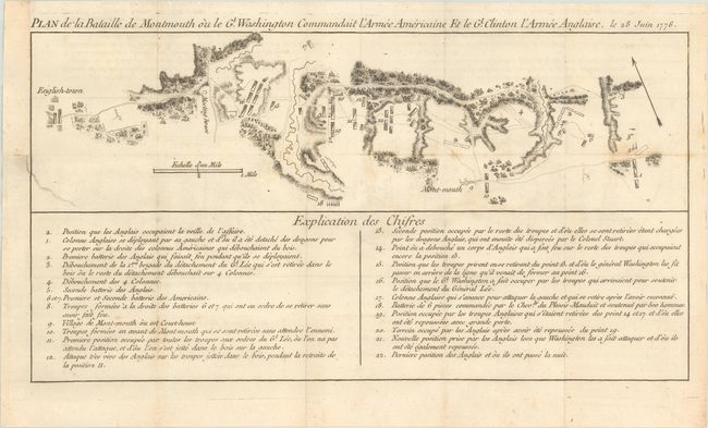
Subject: Monmouth, New Jersey

Period: 1782 (published)

Publication: Essais Historiques et Politiques sur les Anglo-Americains

Color: Black & White

Size:
15.4 x 8.1 inches
39.1 x 20.6 cm
Download High Resolution Image
(or just click on image to launch the Zoom viewer)

This scarce plan is the only plan of the Battle of Montmouth published during the American Revolution. One of the longest battles of the war, Monmouth was also the last major confrontation between the American and British armies in the North. The positions held by both armies are depicted, as well as the deep ravines that played a key role in the battle. An arrow points north toward the upper-left, and a numbered key at bottom gives lengthy explanations of the various movements made by both armies during the battle. The map appeared in Michel Rene Hilliard d'Auberteuil's Essais Historiques et Politiques. The source of the map is attributed to Michel du Chesnoy, an aide to Lafayette during the battle.

References: Nebenzahl (Biblio Amer Rev) #140; Nebenzahl & Higginbotham (Amer Rev) #30.

Condition: B+

Issued folding on watermarked paper with minor foxing and offsetting, and an archivally repaired 1.5" binding tear at left.

Estimate: $1,200 - $1,500

Unsold

Closed on 4/17/2019

Archived