Catalog Archive
Auction 172, Lot 11

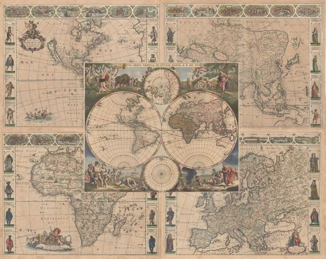
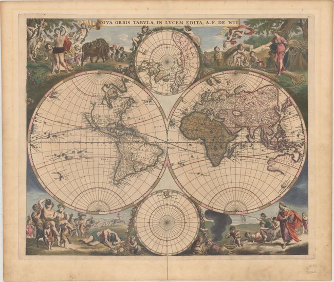
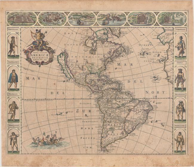
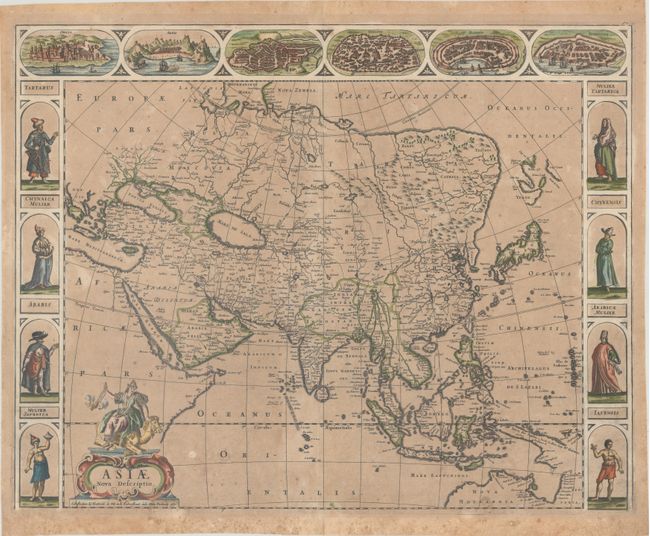
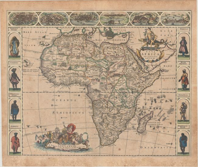
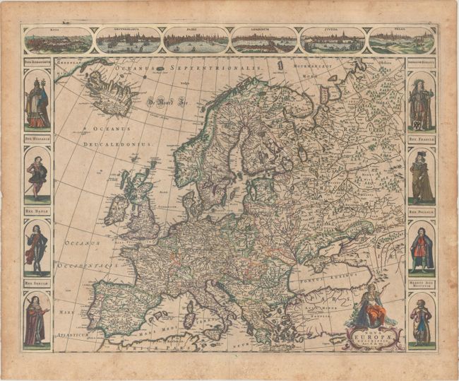
A Stunning Set of Carte-a-Figures Maps

"[Lot of 5] Nova Orbis Tabula, in Lucem Edita [and] Nova Totius Americae Descriptio [and] Asiae Nova Descriptio [and] Nova Africa Descriptio [and] Nova Europae Descriptio", Wit, Frederick de

Subject: World & Continents

Period: 1660-70 (circa)

Publication:

Color: Hand Color

Size:
See Description
Download High Resolution Image
(or just click on image to launch the Zoom viewer)

This magnificent set of carte-a-figures maps was issued by noted Dutch map publisher, Frederick de Wit. It includes the rare set of maps of the four continents first published in 1660, and a separately published world map that Shirley dates circa 1670.

A. Nova Orbis Tabula, in Lucem Edita, circa 1670 (21.8 x 18.3"). This is one of the most attractive double-hemispherical world maps of the late seventeenth century. The corners are filled with images of the seasons, the zodiac, and the elements, all combined within four well-composed vignettes. At top left is a personification of Spring, who also represents Virgo, with the element of Air billowing her robes. The bull of Taurus and the ram of Aries are shown to the right. The top right vignette represents Summer, with the shore in the background illustrating the element Water. A putti holds a crab representing Cancer, and another holds the lion of Leo. The twins of Gemini flank the inset of the North Pole at top. The lower left scene presents Autumn and Earth with a wine-imbibing Bacchus and a scene of drunkenness. The signs for Scorpio and Libra are held by two followers, while Sagittarius gallops in the background. Winter holds court in the final vignette, with the element of Fire shown to the left. Aquarius is represented by a child pouring water into a basin. A group of raucous children in the background hold a goat representing Capricorn and a fishing pole with the double fish of Pisces.

In North America, the Great Lakes appear as one large semi-circle with an open western end, and the island of California is shown on the Briggs model with a flat northern coast, and a portion of Anian appears in the Pacific Northwest. South America has the mythical L. Parime astride the equator, with the imaginary golden city of Manoa on its shores. Asia displays a Japan with an oversized Iedso (Hokkaido) shown on the map of the Western Hemisphere. A partial coastline for Australia is shown, and both New Zealand and Tasmania are indicated by only one stretch of coastline. The inset of the North Pole shows Hudson Bay with two southern bays, and the inset of the South Pole is nearly blank save for the very tip of South America and Tierra del Fuego. This is the first state of the plate without cherubs in the cusps and no outside border. Reference: Shirley #451. Condition: Full contemporary color with a 2" centerfold separation at bottom that has been closed on verso with old paper. There is light surface soiling, a few spots of foxing, and some old ink has been used to "cover up" one of the figures at top left (not an unusual practice). (B+)

B. Nova Totius Americae Descriptio, dated 1660 (21.8 x 17.3"). An uncommon and splendid carte-a-figures map of the Americas. The map combines many different sources including the Luke Foxe model of the island of California. The only hint of the Great Lakes is a small L. Contenant at the end of the St. Lawrence River. Nieu Neder Land occupies the eastern seaboard and there is no mention of any English settlement other than the name Virginia. In South America a large river and lake system provides the boundary of Brazil, with the mythical lake Eupana Lacus. A second mythical lake, Parime Lacus, is shown along the equator. The decorations were taken from van den Keere's map of 1614. The figures at sides depict the natives of Virginia, Magellanica, and Brazil, and the cities across the top include Cusco, Mexico, Olinda, Havana, S. Dominique, and Cartegena. The map is further embellished with a title cartouche bearing a native Indian mounted on an armadillo, and Neptune frolicking in the Pacific with mermaids and sea horses. This is the first state of this separately issued map. References: Burden #356; McLaughlin #24; Tooley (America) #18. Condition: On watermarked paper with light toning, scattered foxing, and a small abrasion in the title cartouche. (B)

C. Asiae Nova Descriptio, dated 1660 (22.1 x 17.4"). This is a splendid example of one of the last Dutch carte-a-figures continental maps. The continent is shown with the northern and eastern coastline of mainland Asia on the Mercator-Hondius model. It incorporates the discoveries made by the 1643 De Vries expedition and the discoveries of Le Maire in New Guinea. The map is illustrated with flanking panels featuring costumed figures from China, Tartary, Arabia and the East Indies. The panels above show panoramas and plans of Ormus, Aden, Jerusalem, Damascus, Rhodes and Famagusta. The title cartouche is adorned by a female representation of the continent riding a camel. Reference: Yeo #51. Condition: On watermarked paper with light toning, scattered foxing, and a 9" edge tear at bottom that has been repaired on verso with archival materials. (B)

D. Nova Africa Descriptio, dated 1660 (21.7 x 17.3"). This is De Wit's uncommon map of Africa. It shows views of Cairo (Alcair), Alexandria, Algiers (Alger), Tunis, Tangiers (Tanger), and Ceuta across the top, which are close copies from Jodocus Hondius' map of Africa from 1623. The figures at both sides of the map are nearly identical to those from Van den Keere's Africa map of 1614, with the exception of the top two (Congensis and Mulier Abissinea). The geography on the map is based on Jodocus Hondius' Africae nova Tabula from 1623, which was copied from Willem Blaeu's Africae nova Descriptio from 1617, although De Wit omits the engravings of animals in the interior. The Nile is shown according to Ptolemy with its sources arising in the lakes Zaire and Zaflan, the fictitious Lake Sachaf of Laurent Fries appears, as well as the R. de Spirito Santo. De Wit's map of Africa was issued separately, as well as in composite Dutch atlases. This is the second state, with "f0 3" outside the upper right border. Reference: Betz #96.2. Condition: On watermarked paper with light toning and scattered foxing. (B)

E. Nova Europae Descriptio, circa 1660 (21.9 x 17.2"). A stunning map of Europe extending to include Iceland and a bit of Greenland. It is flanked at sides with portraits of eight European monarchs. Six vignette views at top show the cities of Rome, Amsterdam, Paris, London, Seville and Prague. The map is very finely engraved and further embellished with a title cartouche surmounted by the personification of Europa. Condition: On watermarked paper with light toning and scattered foxing. (B)

References:

Condition:

See description above.

Estimate: $11,000 - $13,000

Sold for: $6,500

Closed on 4/17/2019

Archived