Catalog Archive
Auction 172, Lot 102

The First Map to Name New Scotland

"[Untitled - Northeastern United States & Canada]", Alexander, William (Sir)

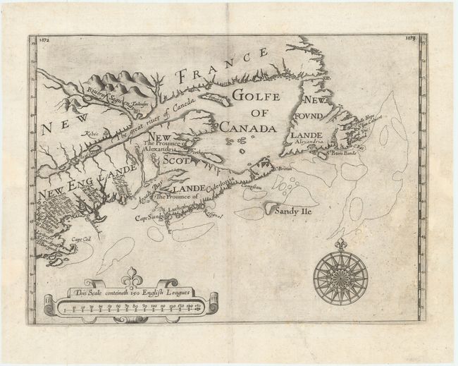
Subject: Colonial Northeastern United States & Canada

Period: 1625 (published)

Publication: Hakluytus Posthumus, or Purchas his Pilgrimes

Color: Black & White

Size:
13.5 x 9.8 inches
34.3 x 24.9 cm
Download High Resolution Image
(or just click on image to launch the Zoom viewer)

This scarce and important map was first published in William Alexander's An Encouragement to Colonies in 1624, and included here in Samuel Purchas' Pilgrimes. Issued to promote colonization in the region, it is cartographically significant for designating New Scotlande and naming Cape Cod for the first time on a printed map.

The Plymouth Council for New England was founded in 1620 to develop the lands between 40 degrees and 48 degrees latitude with 40 initial investors. In 1621, William Alexander received a Royal Charter from James I for the region to the east and north of the St. Croix River which he named New Scotlande (present-day Nova Scotia). After several years of struggle and in recognition that their claims overlapped with Alexander's charter, the Plymouth Council revised its list of patentees down to 20 in 1623 and refined their interests as being to the south of Alexander's charter. These 20 names appear for the first time on this map as a sequence of crowded names along the coast from Cape Cod to Maine, here labeled New Englande. Alexander introduced several other Scottish names in New Scotlande including Caledonia, Forthe, Tweede, and renamed the St. Croix River to the "Clyde River" because it separated New England from New Scotland. Despite Alexander's best efforts, New Scotlande failed to flourish and the region was eventually ceded to the French in 1632. Several sources of information were used in compiling this map including Champlain (1612-13), De Laet, and Mason. Other cartographic milestones include the location and extent of Placentia Bay, the first mapping of Kebec on an English map, and an island in the position of Prince Edward Island (although it is not named). Decorated by a large compass rose and strapwork cartouche containing the distance scale. This is the second state of the map with page numbers in the upper corners.

References: Burden #208; Kershaw #86; Schwartz & Ehrenberg, plt. 54.

Condition: A

A dark impression on a bright sheet with some areas of minor paper weakness that have been professionally reinforced and a few light surface abrasions along the right border. Minor soiling.

Estimate: $6,000 - $7,500

Unsold

Closed on 4/17/2019

Archived