Catalog Archive
Auction 171, Lot 340

NO RESERVE

"A Map of the West-Indies or the Islands of America in the North Sea; with ye Adjacent Countries; Explaning What Belongs to Spain, England, France, Holland &c...", Moll, Herman

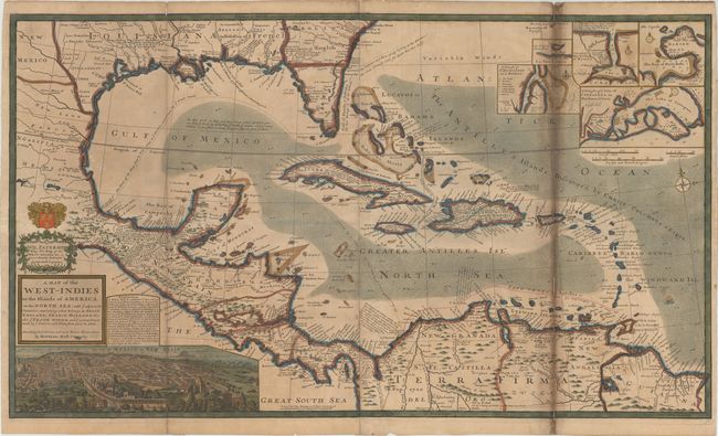
Subject: Gulf of Mexico & Caribbean

Period: 1720 (circa)

Publication:

Color: Hand Color

Size:
39.8 x 22.9 inches
101.1 x 58.2 cm
Download High Resolution Image
(or just click on image to launch the Zoom viewer)

This large and incredible chart is filled with so much information, notes, place names, and interesting configurations that it almost defies description. The map itself extends west to include the Rio Grande, south to northern South America, east to include the Bahamas and the Caribbean, and north just to show Charles Town. The rich silver mining area of Caouila (Coahuila) is shown in New Mexico. Louisiana occupies the entire Gulf Coast and is noted as being in Possession of ye French. Florida is depicted in the triangular form and is called the region of Lakes, Morasse's and Broken Land. Georgia extends west to the Apalaxy River and is labeled Carolina - English. Texas is not named, but the region is labeled Quelameloueches (a possible reference to the Comanche Indians) and is a Country full of Beeves. This region extends to name New Mexico, which itself is above New Leon in northern Mexico. An interesting notation describes the route used to transport cannons to Acapulco. Many details in the Caribbean Sea and Gulf of Mexico relate to the routes of Spanish galleons and there are many other notes on the Trade Routes to Spain. The lines of longitude show the number of hours difference from London. A large inset of Mexico City fills the left quadrant of the map and five smaller insets detail Havana, St. Augustine, Portobello, Cartagena and Vera Cruz. A dedication cartouche to Sir William Paterson, who died in 1719, is topped by a coat of arms. Paterson founded the Bank of England, was a prominent trader in the West Indies, and was the main proponent of the infamous Darien scheme. The imprints of Thomas and John Bowles appear at bottom center. Printed on two sheets, joined as issued.

Herman Moll was one of Britain's most prominent cartographers of the first half of the 18th century. He emigrated from Germany and went to work as an engraver for Moses Pitt in 1678. Soon he joined one of London's most interesting social circles, which gathered at Jonathan's Coffee House, and included stock speculators, scientists, archaeologists, authors, pirates, and sea-captains. From these friends, Moll gained a great deal of privileged information that he compiled into his cartographic works. Moll's success and prosperity was due in part to his social connections and political astuteness, and to his distinctive style and quality workmanship. He produced a great number of often-innovative maps, charts, globes, atlases and geographies. His best known works are the large two-sheet maps produced for his World Described, which were also published separately.

References: cf. Shirley (BL Atlases) T.MOLL-4b #10.

Condition: C+

Issued folding with light toning and soiling overall and an extraneous horizontal fold. There is dark toning along the right-hand fold that was caused by an old paper repair that was meant to close a number of fold separations, however several have re-emerged. There are additional separations along the left-hand fold and the horizontal fold, as well as a few tiny chips along the edges of the sheet. With some professional paper restoration this could be a lovely example.

Estimate: $1,500 - $1,800

Sold for: $325

Closed on 2/6/2019

Archived