Catalog Archive
Auction 171, Lot 258

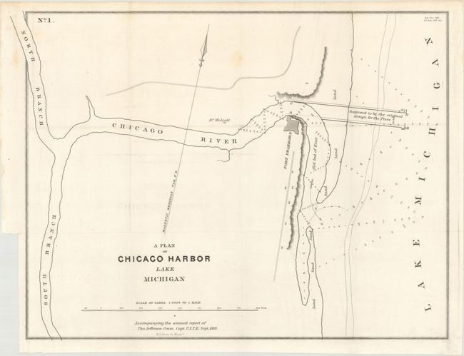
Early Map of Chicago

"A Plan of Chicago Harbor Lake Michigan", Cram, Thomas Jefferson (Capt.)

Subject: Chicago, Illinois, Lake Michigan

Period: 1839 (dated)

Publication: Sen. Doc. 140, 26th Congress, 1st Session

Color: Black & White

Size:
14.9 x 11.2 inches
37.8 x 28.4 cm
Download High Resolution Image
(or just click on image to launch the Zoom viewer)

This is one of the earliest map of Chicago Harbor, when the population of the entire city was about 4,500. Fort Dearborn, the first recognized structure of Chicago, and Dr. Wolcott's residence are the only two buildings located. Soundings are noted in the Chicago River and Lake Michigan.

This map was issued in the 26-page Report from the Secretary of War, Transmitting Copies of Reports of the Topographical Bureau in Relation to Internal Improvements in the Territory of Wisconsin... by Captain Thomas Jefferson Cram of the Topographical Engineers (report not included). Cram (1804-1883) was born in New Hampshire and graduated fourth in his class from the United States Military Academy in West Point, New York. In 1838, he joined the U. S. (Army) Topographical Engineers, where he received a captain's commission and was assigned to the Great Lakes harbor surveys. In the 1840s he surveyed the Michigan and Wisconsin boundary, and in 1855 he became Chief of the Topographical Engineers, Western Division. He was promoted to Lt. Colonel in 1861, served with distinction in the Civil War and was rewarded with the title of Brevet General in 1866. He retired in 1869.

References: Claussen & Friis #330.

Condition: A

Issued folding on a clean sheet with one faint spot and just a hint of offsetting.

Estimate: $700 - $850

Sold for: $250

Closed on 2/6/2019

Archived