Catalog Archive
Auction 170, Lot 94

"America Septentrionalis, Concinnata Juxta Observationes Dnn. Academiae Regalis Scientiarum...", Wolff, Jeremias

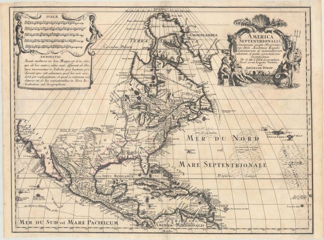
Subject: Colonial North America

Period: 1710 (circa)

Publication:

Color: Black & White

Size:
23.6 x 17.8 inches
59.9 x 45.2 cm
Download High Resolution Image
(or just click on image to launch the Zoom viewer)

This attractive map is a very scarce German version of Guillaume Delisle's foundation map of North America (1700). The Great Lakes are based on the Coronelli model showing the French strong points at Tadousac, Quebec, Fort Sorel, Montreal and Fort Frontenac. The English settlements are confined along the eastern seaboard with the region around the Great Lakes and north of the Ohio River being the domains of the Ilionensium and Iroquoens. As with Delisle's map, the Mississippi River is properly aligned, as are the Rio Grande and Colorado rivers, and California appears as a peninsula. Numerous tracks in the Pacific show the routes of different voyages. The Sargasso Sea is depicted in the Atlantic. Graphically the map copies both the title and the sales & notations cartouches.

References: McCorkle #700.4; Portinaro & Knirsch CXXIV.

Condition: B

A dark, sharp impression on paper with a fleur-de-lis coat of arms watermark and issued folding. There is light toning and soiling, as well as a number of archival repairs to fold separations and some short tears in the image. A 1/2" hole below the title cartouche has been professionally repaired. The map has also been professionally remargined at left and right, with loss of the border at left, although the neatline has been seamlessly replaced in facsimile. Despite these imperfections, the map presents itself very well.

Estimate: $550 - $650

Sold for: $275

Closed on 11/14/2018

Archived