Catalog Archive
Auction 170, Lot 87

A Rare Map with a Plethora of Fictitious Lakes

"A New Map of North and South America from the Best Authorities and Astronl. Observatns.", Kitchin, Thomas

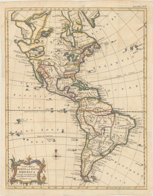
Subject: Western Hemisphere - America

Period: 1759 (published)

Publication: Universal Gazetteer

Color: Hand Color

Size:
11 x 14.1 inches
27.9 x 35.8 cm
Download High Resolution Image
(or just click on image to launch the Zoom viewer)

This rare and interesting map includes numerous geographical misconceptions. A large Sea of the West is shown with several islands and a notation that Juan de Fuca sailed through the sea in 1592. The two inlets to the sea are noted as discovered by Juan de Fuca in 1592 and Martin de Aguilar in 1603. Several other fictitious lakes appear further north, including Lake Valasco, De Fonte's Lake, and Bernarda Lake. The British Colonies extend to the Mississippi River, with New York extending west of Pennsylvania into Michigan. In South America, the mythical lake L. des Xarayes is shown as the source of the Paraguay River. Adorned with a lovely rococo cartouche that features a dragon. This map is quite rare as we've only found one other example listed for sale in the last 30 years.

References: McGuirk #77.

Condition: B+

Issued folding, now flattened, on paper with a large coat of arms watermark and very light offsetting. A binding trim at left has been replaced with period-correct paper, and an adjacent binding tear that enters 1" into image at left has been archivally repaired.

Estimate: $350 - $450

Sold for: $650

Closed on 11/14/2018

Archived