Catalog Archive
Auction 170, Lot 680

"Partie de la Mer du Sud Comprise Entre les Philippines et la Californie d'Apres la Carte Espagnole Trouvee sur le Galion pris par l'Amiral Anson... [on sheet with] ... d'Apres une Autre Carte Espagnole Communiquee a la Perouse...", La Perouse, Comte Jean F. Galoup, de

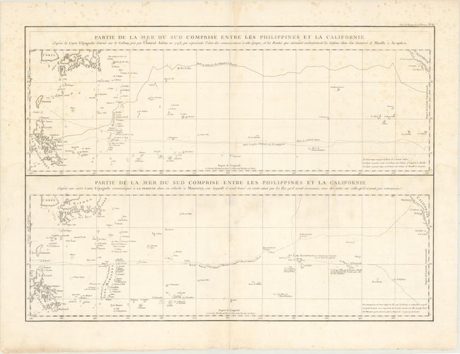
Subject: Pacific Ocean

Period: 1797 (circa)

Publication: Atlas du Voyage de la Perouse

Color: Black & White

Size:
26.6 x 19.3 inches
67.6 x 49 cm
Download High Resolution Image
(or just click on image to launch the Zoom viewer)

Jean-Francois de Galoup, Comte de La Perouse commanded a French scientific expedition to the Pacific in 1785-88. Recognized as one the foremost naval commanders and navigators in France, he was selected by King Louis XVI to complete Captain James Cook's exploration of the western Pacific. The British Admiralty provided scientific equipment to measure variations in magnetic compass readings and with the latest instruments for determining longitude. La Perouse explored the coasts of the Gulf of Alaska and northwestern North America in search of the fabled Northwest Passage. After leaving America his expedition continued on to Asia where he explored from Macao to Kamchatka and the Solomon Islands in the South Pacific. La Perouse was meticulous in sending copies of his extensive logs, maps and surveying information via other ships as well as overland. La Perouse's last contact was in the spring of 1788 with a British ship in Botany Bay, Australia. The expedition was never heard from again. Considered one of the greatest French voyages, the French Government decided to publish the story of the expedition when it became clear they had been lost. An English edition was published in London.

An interesting large sheet with two maps that cover the same area of the central Pacific. The top chart shows the routes of the Spanish galleons from Acapulco to the Philippines along with the track of Commodore Anson. This chart does not show the Hawaiian Islands, as they were unknown to the Spanish. The bottom chart shows La Perouse's route from Monterey, through Hawaii and the Mariannes, to Macao.

References: Shirley (BL Atlases) G.LPR-1a #67.

Condition: B+

On a watermarked sheet with light scattered foxing and a small tear near the sheet's center that has been repaired with archival materials on verso.

Estimate: $180 - $210

Sold for: $110

Closed on 11/14/2018

Archived