Catalog Archive
Auction 170, Lot 383

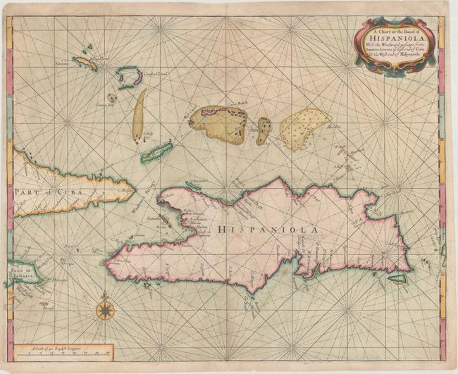
"A Chart of the Iland of Hispaniola, with the Windward Passage from Iamaica Betwene ye East End of Cuba & the West End of Hispaniola", Thornton & Seller

Subject: Hispaniola

Period: 1713 (circa)

Publication: The English Pilot, Fourth Book

Color: Hand Color

Size:
21.1 x 16.5 inches
53.6 x 41.9 cm
Download High Resolution Image
(or just click on image to launch the Zoom viewer)

This is a very scarce chart of the island of Hispaniola showing the Windward Passage, the important shipping lane between Cuba and Hispaniola that connects the Caribbean Sea with the Atlantic. The map is from the important first English sea-atlas of American waters. br>
John Seller was a pioneering British publisher of nautical charts and one of the most important figures in the early history of British cartography. Seller's shop, located near the Tower of London in Wapping, became a gathering place for seamen arriving with the latest news of distant places such as the West Indies and provided Seller with information critical to his nautical chart business. In addition to sea charts, he produced a vast array of cartographic material, the first to rival the large Dutch firms such as Blaeu and Jansson. Seller was appointed Royal Hydrographer by Charles II in 1671, and also served under James II and William III. Unfortunately his business was built on a shaky foundation and though he made several attempts to avoid bankruptcy including a consortium partnership with other cartographers such as William Fisher and John Thornton, he was ultimately unsuccessful.

References: Shirley (BL Atlases) M.THOR-2a #12.

Condition: B+

A crisp impression on paper with a watermark of the initials "GSH." There is light toning and soiling, and a long printer's crease adjacent to the centerfold. There are professional repairs to several tears just to the right of the centerfold at bottom and center.

Estimate: $500 - $650

Sold for: $700

Closed on 11/14/2018

Archived