Catalog Archive
Auction 170, Lot 374

Important map of the Florida Peninsula from the War of Jenkin's Ear

"Nova Tabula Exhibens Insulas Cubam et Hispaniolam Vulgo S. Domingo Dictam Insulas Lucaias seu Bahamanas ac Peninsulam Floridae...", Ottens, Reiner and Joshua

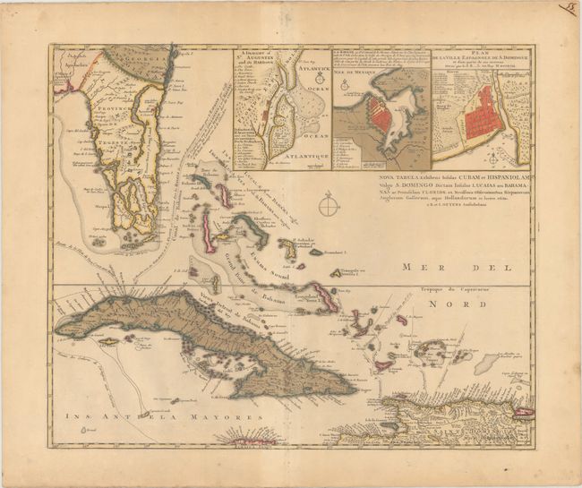
Subject: Florida, Cuba & Bahamas

Period: 1740 (circa)

Publication:

Color: Hand Color

Size:
21.3 x 17.6 inches
54.1 x 44.7 cm
Download High Resolution Image
(or just click on image to launch the Zoom viewer)

This important map of the Florida peninsula, Cuba, the Bahamas, and part of Hispaniola was prepared at the time of the War of Jenkin's Ear between Britain and Spain. The map details the route of the Spanish treasure ships arriving in Havana from Spain, and then heading south towards Cartagena. Three insets at top depict the harbors of St. Augustine, Havana, and Santo Domingo. The map was issued separately and as part of a large six-part map illustrating the War of Jenkin's Ear in 1740-41. This is the separately issued state as it contains its own title cartouche.

References:

Condition: B+

Lovely original color with light toning and a few spots of foxing primarily along the centerfold at bottom. There is one tiny crack along the southern shore of Cuba that has been archivally repaired on verso.

Estimate: $2,000 - $2,400

Sold for: $1,100

Closed on 11/14/2018

Archived