Catalog Archive
Auction 170, Lot 204

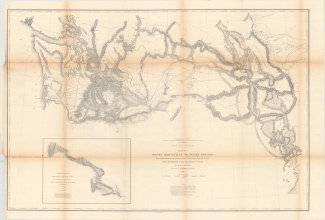
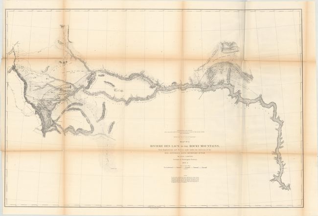
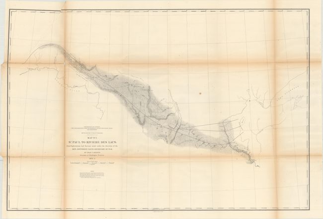
Survey for a Northern Route for the Pacific Railway

"[Lot of 3] Map No. 1 St. Paul to Riviere des Lacs... [and] Map No. 2 Riviere des Lacs to the Rocky Mountains... [and] Map No. 3 Rocky Mountains to Puget Sound...", Stevens, Isaac Ingalls

Subject: Western United States

Period: 1853-54 (dated)

Publication: U.S. Pacific Railroad Surveys

Color: Black & White

Size:
36.7 x 24.4 inches
93.2 x 62 cm
Download High Resolution Image
(or just click on image to launch the Zoom viewer)

During the 1850s, the U.S. government sponsored an extensive series of expeditions designed to gather information on the vast new territories that had been acquired in western North America. The discovery of gold in California further stimulated westward traffic and heightened the need for a faster and more convenient way to bring the far-flung parts of the country together. In 1853 Congress commissioned the Army's Topographic Bureau to conduct a series of surveys to find a suitable route for a transcontinental railroad. There were six major expeditions; five of them covered the area between the Great Plains and west coast, and the sixth explored the coastal states of California and Oregon. All of these expeditions were accompanied by naturalists and artists to document the landscape, flora and fauna along the route. The reports, maps and lithographs were published in the 13 volume report "Explorations and Surveys to ascertain the most practicable and economical route for a Railroad from the Mississippi river to the Pacific Ocean."

This set of three maps details the Stevens survey for a route for the Pacific railway that would connect the Mississippi River with the Pacific Coast, thereby opening up the trade route to Asia. After being named Governor of the newly created Washington Territory in March 1853, Stevens made his way across the northern plains while completing the survey. His work was published in Report of Explorations for a Route for the Pacific Railroad near the 47th and 49th Parallels of North Latitude, from St. Paul, Minnesota, to Puget Sound and included these three maps. The maps offer excellent detail along the route and are filled with place names, forts, and unexplored areas. Mountain terrain is indicated through fine hachuring.

A. Map No. 1 St. Paul to Riviere des Lacs. This map details Stevens' survey efforts between St. Paul and Fort Snelling along the Plateau of the Missouri to a spot north of Union on the Yellowstone River. Locates Forts Snelling, Ripley, Union, Clark, and Berthold.

B. Map No. 2 Riviere des Lacs to the Rocky Mountains. This map details the Stevens surveys beginning on the Missouri River at Fort Pierre and culminating at the Continental Divide of the Rockies. The route travels along the Plateau of the Missouri to Fort Benton (Missoula) and on to the Continental Divide at Lewis and Clark Pass. Locates Hell's Gate Passes to the south.

C. Map No. 3 Rocky Mountains to Puget Sound. This is an excellent and complex map that details the many routes of McClelland, Gibbs, Donelson, Arnold, Saxton, and Mullan, to name just the majority of survey parties. It clearly indicates the great difficulty of finding a railroad route through the numerous mountain ranges. With a large inset of "Reconnaissance of the Railroad Route From Walla Walla to Seattle via Yak-e-mah River & Snoqualmie Pass." Extends east to the Rocky Mountains to include Lewis & Clark Pass, Flathead Lake, and south to Fort Hall.

References: Wheat (TMW) #862.

Condition: B

Issued folding, with light toning along the folds, minor foxing, a few extraneous creases, and short separations along the folds. Map No. 1 has a small amount of loss along the fold at left and an adjacent 5" tear that has been closed on verso with archival tape. Map No. 3 has a 7" separation at left that has also been closed with archival tape on verso.

Estimate: $350 - $425

Sold for: $150

Closed on 11/14/2018

Archived