Catalog Archive
Auction 170, Lot 196

"Map Illustrating the Plan of the Defences of the Western & North Western Frontier, As Proposed by Charles Gratiot, In His Report of Oct. 31, 1837", Gratiot, Charles

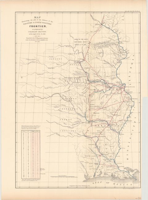
Subject: Central United States

Period: 1837-60 (circa)

Publication: American State Papers

Color: Hand Color

Size:
15 x 21 inches
38.1 x 53.3 cm
Download High Resolution Image
(or just click on image to launch the Zoom viewer)

This map is from the series of maps that illustrated the factious Congressional debate over the nature of the frontier defenses in the region between the Mississippi River and the Rocky Mountains. Issued under the direction of Col. J. J. Abert by W. Hood, the map depicts the states of Missouri, Arkansas, Louisiana and the Indian nations bordering them to the west. It shows the locations of many military forts and outposts from Ft. Jessup to Ft. Snelling with notations throughout concerning lands ceded by several Indian nations with the dates of the treaties. The threat posed by hostile Indians, whose numbers greatly exceeded those of the area's settlers, resulted in a protracted Congressional debate concerning the defenses required along the frontier. Gratiot’s defense plan uses color to trace the common roads and rivers. A table at lower left notes the distances between forts and the equivalent "days of march" at 15 miles per day. This is the later printing (ca. 1860) issued in the American State Papers.

References: cf. Wheat (TMW) #427.

Condition: B+

Clean and bright. Issued folding and now flattened and backed with tissue to reinforce and repair two long separations along the vertical fold.

Estimate: $140 - $170

Sold for: $100

Closed on 11/14/2018

Archived