Catalog Archive
Auction 170, Lot 186

Features the First Printed Map of the Southern United States

"Peruviae Auriferae Regionis Typus [on sheet with] La Florida [and] Guastecan Reg.", Ortelius, Abraham

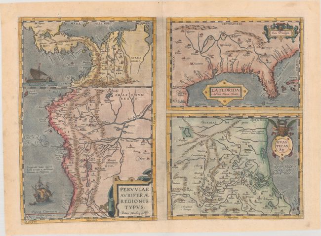
Subject: Southern United States, Central America & Peru

Period: 1584 (published)

Publication: Theatrum Orbis Terrarum

Color: Hand Color

Size:
18.1 x 13.1 inches
46 x 33.3 cm
Download High Resolution Image
(or just click on image to launch the Zoom viewer)

This was one of the few sixteenth century maps based on Spanish sources; in this case drawing from reports of Hernando de Soto's expedition through the region. There are three maps on this sheet. The most important map, La Florida, is the first printed map of the southern portion of the United States. This influential map provided the foundation cartography for the region, particularly in the depiction of the river systems. The map below (Guastecan Reg) combines with La Florida to extend the coastline of the Gulf of Mexico further south. The third is a map of Peru, where De Soto was the first Spaniard to meet Inca Emperor Atahuallpa. In the north of the map of Peru is Aurea Regio, or Kingdom of Gold, a reference to the fabled El Dorado. All maps contain decorative cartouches, and the map of Peru is embellished with two ships. Latin text on verso.

References: Burden #57; Cumming (SE) #5; Van den Broecke #15.

Condition: A

A dark impression with the crossed arrows watermark commonly found on Ortelius' maps. There is some printer's ink residue and a pair of small wormholes in the image at top.

Estimate: $1,100 - $1,400

Sold for: $800

Closed on 11/14/2018

Archived