Catalog Archive
Auction 170, Lot 112

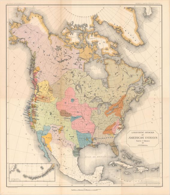
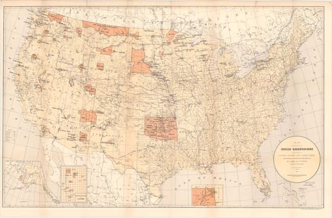
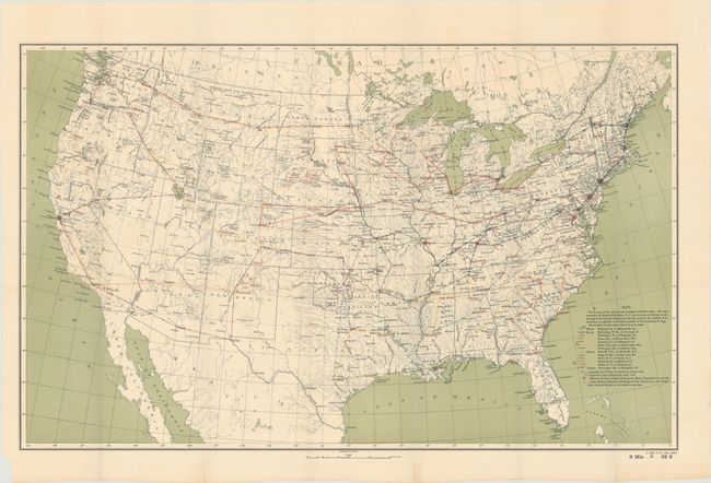
"[Lot of 3] Linguistic Stocks of American Indians North of Mexico [and] Map Showing the Location of the Indian Reservations... [and] [Untitled - Map Showing Routes Followed by 13 Examiners of Indian Reservations and Schools]",

Subject: North America, Indians

Period: 1885-93 (published)

Publication:

Color: Printed Color

Size:
See Description
Download High Resolution Image
(or just click on image to launch the Zoom viewer)

A. Linguistic Stocks of American Indians North of Mexico, by J.W. Powell, from 7th Annual Report of the Bureau of Ethnology, published 1891 (17.5 x 20.3"). This colorful and useful map helps to understand the possible early linguistic relationships of the various Native American Tribes. This is the first edition and the basis for a similar map that appeared later in the 11th Census of the United States. A small map of the Aleutian Islands is inset at lower left. Chromolithographed by the New York firm of Sackett & Wilhelms. The map was compiled under the direction of Henry Gannett. Gannett (1846-1914) established the geography program in the U.S. Census Office for the tenth (1880) census. In 1882 he created a similar program at the USGS, which became the Division of Geography in 1885 and produced the first topographic map sheets published in the General Atlas of the United States four years later. Condition: A clean and colorful example, issued folding. (A)

B. Map Showing the Location of the Indian Reservations Within the Limits of the United States and Territories..., by the Department of the Interior, published 1885 (33.5 x 21.1"). This large map of the United States focuses on the many Indian Reservations in the United States as of 1885. The reservations are named and shown in orange overprinting. The map also shows military stations, towns and villages, railroads, and Indian agencies. Includes insets of Alaska, Indian Territory, and Mission Indian Reservation (California) at bottom. Compiled under the direction of John Atkins, Commissioner of Indian Affairs. Condition: Issued folding with a 4" binding tear at left that has been closed on verso with archival tape. (B+)

C. [Untitled - Map Showing Routes Followed by 13 Examiners of Indian Reservations and Schools], by U.S. Geological Survey (USGS), from Senate Misc. Doc. 61, 52nd Congress, 2nd Session, published 1893 (28.3 x 17.4"). This untitled map was used by the U.S. Indian Commission to report on the status of the various Indian tribes. The routes of 13 examiners are shown in various line color with a corresponding key at bottom right. The map also locates all Indian reservations, Indian schools, and the Quartermaster Depots that served them. Condition: Issued folding on a clean, bright sheet. (A)

References:

Condition:

See description above.

Estimate: $200 - $250

Sold for: $150

Closed on 11/14/2018

Archived