"Daniel Taverniers Land Charte des Konigreichs Tunquin",
Subject: Southeast Asia
Period: 1684 (circa)
Publication: Delineatio Provinciarum Pannoniae...
Color: Black & White
Size:
6.4 x 8.2 inches
16.3 x 20.8 cm
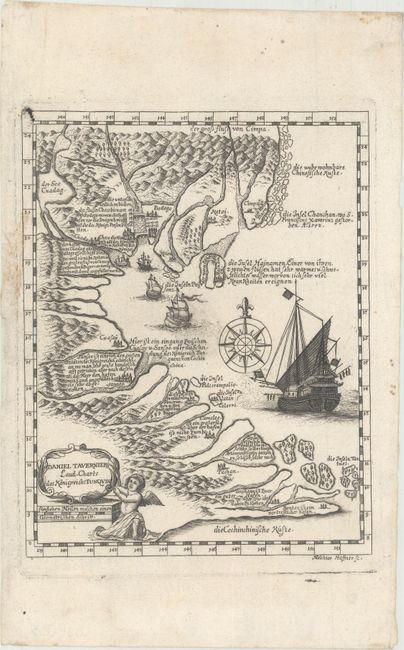
This is a German edition of Daniel Tavernier's map of the region. Tavernier had made a dozen voyages to Tonkin in the 1640s, and his brother Jean Baptiste published his map in 1679 as an addendum to his own account of voyages to the region, where he was a notable diamond trader.
The map itself covers the full Indochinese coast. At the bottom is a very distorted Mekong Delta with Con Son island identified as Die Inseln Tortues (island of turtles). Notations fill the map describing the land and its features, and is augmented by lovely depictions of topography and settlements. The map is decorated by a large Asian ship, several smaller European ones near the coast, and a compass rose with fleur-de-lis. The decorative title cartouche is held up by a cherub.
This edition was engraved by Melchior Haffner and published in Wagner's Delineatio Provinciarum Pannoniae.
References: Suarez (Early Mapping of Southeast Asia) pp. 216-218.
Condition: A
A dark impression on a clean sheet of watermarked paper. There are very minor imperfections confined to the blank margins.