Catalog Archive
Auction 169, Lot 353

"A Plan of the Havanna with the Different Attacks in the Siege 1762 Drawn on the Spot", Gibson, John

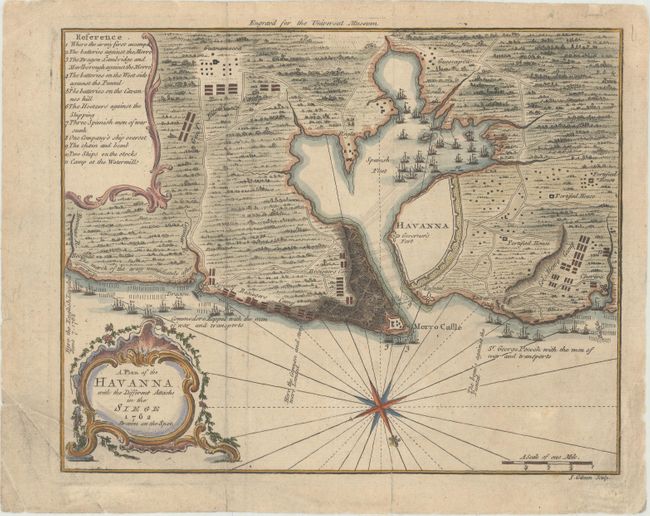
Subject: Havana, Cuba

Period: 1762 (dated)

Publication: Universal Museum

Color: Hand Color

Size:
9 x 7.1 inches
22.9 x 18 cm
Download High Resolution Image
(or just click on image to launch the Zoom viewer)

This highly detailed battle map was published in the October 1762 edition of the British periodical, Universal Museum. The plan of the harbor and region around Havana show the location of warships and other important details during the successful attack of British forces on Havana. This 1762 siege was the final battle in the Americas at the end of the French and Indian War. Locates the fortified city of Havana, Puntal, Guadalupe, Lazaro, Corera, Guescapoa, Guanamacoa, Boconoa, and Cojimar. A large number of British warships float offshore and another 18 are in the harbor south of Havana. Also locates the camps of Col. How and General Elliot, and a large Besieging Camp is on Cavanna's Hill behind the fortified town of Morro. A numbered key identifies various points of interest on the map. Decorated with a large compass rose orienting north to the bottom right and a rococo cartouche. An uncommon edition.

References: Jolly #UMUS-8.

Condition: B+

Issued folding, now flattened, with minor toning and soiling and a couple of extraneous creases at bottom left. Several short tears and separations are almost entirely confined to the blank margins and have all been archivally repaired on verso.

Estimate: $180 - $210

Unsold

Closed on 9/12/2018

Archived