Catalog Archive
Auction 169, Lot 198

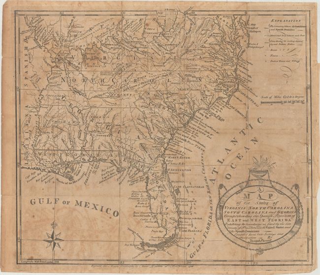
Rare First State of Purcell's Map Locating the Proposed State of Franklin

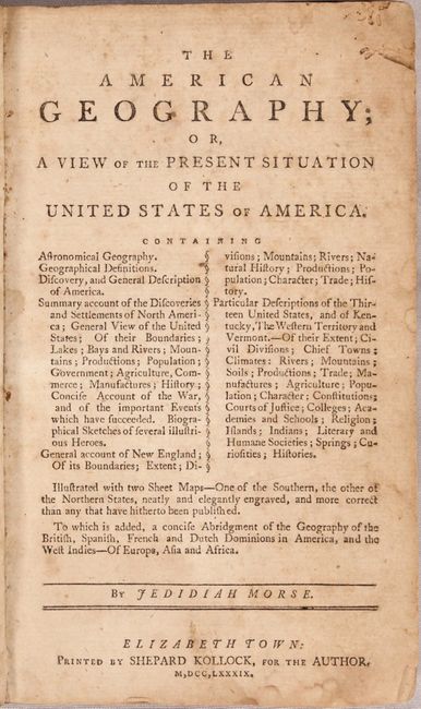
"[Lot of 2] A Map of the States of Virginia, North Carolina, South Carolina and Georgia; Comprehending the Spanish Provinces of East and West Florida... [with] The American Geography...", Morse, Jedidiah (Rev.)

Subject: Southern United States, Franklin

Period: 1789 (published)

Publication:

Color: Black & White

Size:
14.4 x 12.3 inches
36.6 x 31.2 cm
Download High Resolution Image
(or just click on image to launch the Zoom viewer)

This map is a fascinating historical document of the United States following the Revolutionary War. It includes an early reference to the New State of Franklin in western North Carolina. The map includes a great amount of information including boundaries claimed by the various Indian Nations and trading paths on the western frontier. It shows early settlements, including a Moravian Settlement in North Carolina, and the Cumberland Settlements in present-day Tennessee. At the top of the map, in the nascent Northwest Territory, the 7 Ranges denote the first application of the Public Land Survey System. Several bounty land grants are shown including the Ohio Company, Wabash Company, New Jersey Company, Illinois Company, and the Donation Lands of the Commonwealth of Virginia. A triangular shaped plot of land in the region of present-day West Virginia is labeled Indiana. In 1785, settlers in present-day western North Carolina and eastern Tennessee organized a state government to be named in honor of Benjamin Franklin, Franklin or Frankland. Congress turned down their appeal but the state maintained a legislature and governor until 1788. This ephemeral state appeared on a small number of maps into the early part of the 19th century. This is the rare first state of Purcell's map, and the first time this state has been listed with OWA.

The map is accompanied by Rev. Jedidiah Morse's The American Geography; or, a View of the Present Situation of the United States of America, published in 1789 in Elizabethtown and printed by Shepard Kollock. The map was originally bound into the volume after the table of contents, but was removed to repair the fold separations. The map of the Northern States that originally accompanied this volume is lacking. Octavo, 534 pp. Hardbound in original full leather with gilt tooling and leather title label on spine.

References: Dotson & Baker (OWA) #3; Baynton-Williams (TMC-72) p. 16, #2; McCorkle (18th C. Geography Books) #299.

Condition: C+

The map has moderate toning, soiling and offsetting. There are several 2-3" fold separations that have been closed with archival tape on verso. A 1" tear at far right and a 0.25" tear in the Gulf of Mexico have also been archivally repaired. There are a couple of tiny holes along the folds. The book is moderately toned and soiled with some foxing. There is a damp stain affecting the first 10 pages of the book. The hinges are starting, the covers are heavily soiled with several chips, and the spine also shows moderate wear with some cracking and a few abrasions.

Estimate: $700 - $850

Sold for: $600

Closed on 9/12/2018

Archived