Catalog Archive
Auction 168, Lot 321

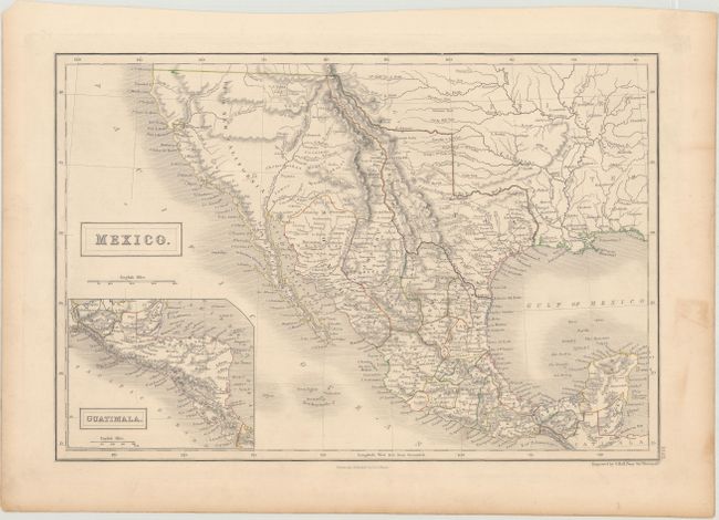
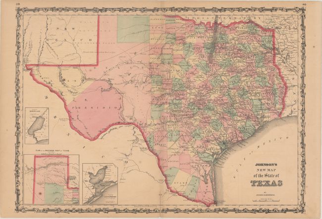
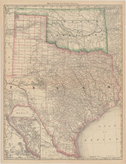
"[Lot of 3] Mexico [and] Johnson's New Map of the State of Texas [and] Map of Texas and Indian Territory",

Subject: Southwestern United States & Mexico, Texas

Period: 1846-83 (circa)

Publication:

Color: Hand Color

Size:
See Description
Download High Resolution Image
(or just click on image to launch the Zoom viewer)

A. Mexico, by Sidney Hall, from Black's General Atlas, circa 1846, hand color (14.6 x 9.9"). This is an attractive representation of the present-day southwestern United States, Texas and Mexico. The map depicts the new state of Texas in its stovepipe configuration, bound by the Rio Grande on its western border. In Upper or New California, there is an American Fur Co. Depot on the eastern shore of L. Youta or Salt L.. The Great Spanish Road is shown from the Red River to Santa Fe, and then heading south through the length of Mexico. The map continues into Central America in an inset of Guatimala. Reference: Day #1508. Condition: Original outline color with minor soiling in the blank margins. (A)

B. Johnson's New Map of the State of Texas, by Johnson & Browning, from Illustrated Family Atlas of the World, published 1861, hand color (24 x 17"). The first edition of this handsome map, with county development mostly in eastern Texas and only the three large counties of El Paso, Presidio, and Bexar in the west. The panhandle, noted as the Staked Plain (Elevated Table Land, without Wood or Water), includes a large section that is unorganized. There are numerous wagon roads, a few completed railroads, and the US Mail Route traced on the chart. Insets include a Plan of Sabine Lake, Plan of the Northern part of Texas, and Plan of Galveston Bay. Surrounded by Johnson's early strapwork border. Blank on verso. Reference: Day #1416. Condition: There is light toning, scattered foxing, and a 2" centerfold separation at bottom that has been repaired on verso with cello tape. (B)

C. Map of Texas and Indian Territory, by Hiram H. Hardesty, circa 1883, printed color (19.1 x 24.8"). Very detailed map of Texas and Indian territory with an inset map of west Texas on the same scale. Shows roads, completed railroads, and projected railroads. Tom Green County is shown in a large, early configuration, not yet divided into Sterling, Irion, Coke, and Midland. This map, however, shows Greer County identified and appearing in Indian Territory and the panhandle is also included in Indian Territory. Printed on thin banknote paper. Condition: Clean, bright, and issued folding. (A)

References:

Condition:

See description above.

Estimate: $350 - $425

Sold for: $650

Closed on 6/6/2018

Archived