Catalog Archive
Auction 168, Lot 235

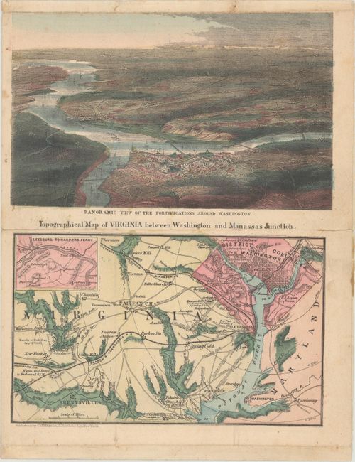
"[View of Washington D.C. and Surroundings with] Topographical Map of Virginia between Washington and Manassas Junction", Magnus, Charles

Subject: Washington, D.C., Civil War

Period: 1863 (circa)

Publication:

Color: Hand Color

Size:
7.8 x 9.9 inches
19.8 x 25.1 cm
Download High Resolution Image
(or just click on image to launch the Zoom viewer)

This uncommon letter sheet map was published during the Civil War. The top panel depicts Washington at the confluence of the Potomac and Anacostia rivers, with Alexandria further downstream. Plumes of smoke are shown in the background, symbolizing the battles taking place in the vicinity. The bottom panel is a detailed map of northern Virginia and Washington. It shows roads, railroads, towns and cities naming Fairfax, Mt. Vernon, Fort Washington, Hunter's Mill, Prospect Hill and Washington D.C. at upper left. At the left of the map is Battle of Bull Run with "Rebel" positions noted. Charles Magnus produced several maps and views during the Civil War and this small work has drawn on his prior work.

The verso of this double-page sheet contains a manuscript letter written by Francis Garman to his mother. The letter was sent from Camp Wire Bridge and dated May 11, 1863. Garman was with the 56th Pennsylvania Regiment as stated in the letter. It appears that Garman was with General Hooker at Fredericksburg and his outfit came within 2 miles of Richmond. About six months before the date of this letter, Union forces suffered one of the worst defeats in the war at the Battle of Fredericksburg (December 1862).

References:

Condition: B+

There is light soiling, faint extraneous creases (folded to fit in a small envelope), and a few small fold separations closed on verso with archival tape.

Estimate: $300 - $375

Sold for: $220

Closed on 6/6/2018

Archived