Catalog Archive
Auction 168, Lot 134

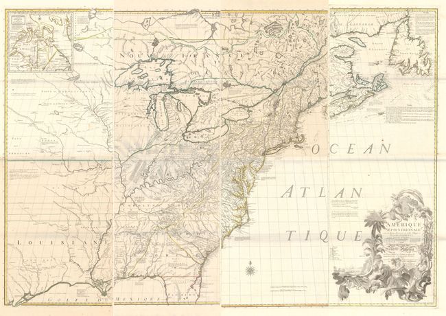
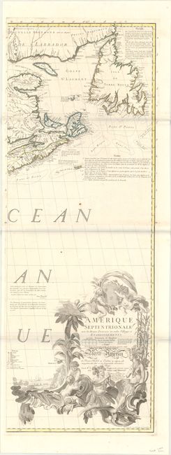
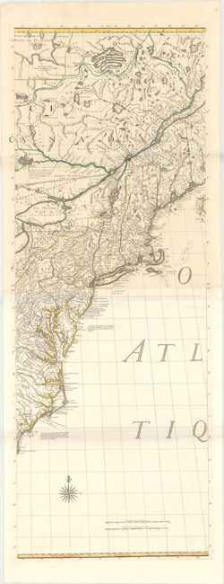
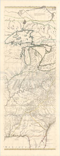
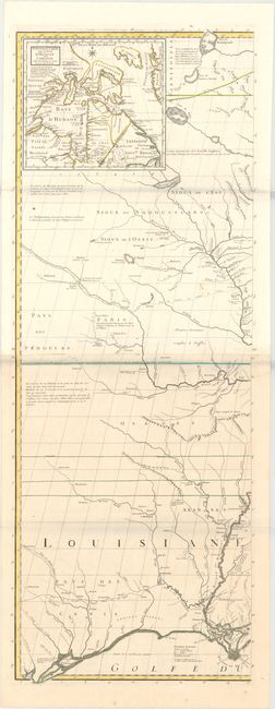
Third French Edition of Mitchell's Monumental Map

"[On 8 Sheets] Amerique Septentrionale avec les Routes, Distances en Miles, Villages et Etablissements... / North America...", Mitchell/Le Rouge

Subject: Colonial Eastern United States & Canada

Period: 1777 (dated)

Publication: Atlas General

Color: Hand Color

Size:
19 x 53 inches
48.3 x 134.6 cm
Download High Resolution Image
(or just click on image to launch the Zoom viewer)

This is the third French edition of John Mitchell's monumental map of eastern North America published by George Le Rouge. It is considered by many to be the most important map of America ever produced. The map was so widely regarded that it was used as the source document to determine the new boundaries of the United States at the Treaty of Paris in 1783. The map continued to be used for nearly all boundary disputes between Canada and the United States in the 19th century.

John Mitchell was a doctor by training, but was also a noted botanist and philosopher. He earned a master's degree in Edinburgh, though he spent most of his first 35 years in eastern Virginia. By 1746, however, Mitchell discovered that the climate in Virginia was too difficult on his health and he moved to London. Through his interest and contributions to botany, he became a member of the Royal Society. It was through this association that he became acquainted with prominent members on the Board of Trade & Plantations. During this time, Mitchell composed a large map of North America based entirely upon public sources in order to educate the British public about the encroaching French. While Mitchell himself believed his map to be inadequate, the commissioners of the Board of Trade were impressed enough to request he make a more detailed map as it had been decades since the last significant map was produced (Popple). Unlike his first map, Mitchell had full access to all available maps belonging to both the Board of Trade and the British Admiralty.

Mitchell's source maps and charts included Fry and Jefferson for Virginia, Christopher Gist for the Ohio Valley, and Colonel John Barnwell for the Southeast. He also consulted French sources in the Mississippi Valley, but was cautious with this information so as not to take a French point of view in this contentious region. The final result of Mitchell's compilation was a decidedly British view of the region. The map's boundaries are color-coded to show the possessions of the English (yellow), French (blue), and a huge area in green west of the Appalachians showing contested lands. In this disputed region, Mitchell prominently depicts the British claims of Virginia and the Carolinas extending well beyond the Mississippi River and off the map and presumably "to the South Sea" per the original charters. A note along the left border of the map indicates that the sources of the rivers and the country beyond this map are not well known. Another notation along the Missouri River indicates that it flows to the west a distance equal to that of the Ohio River flowing east, demonstrating a common belief at the time of symmetrical geography. The overall level of detail provided is unlike any preceding map and includes copious useful notations describing the land, rivers, Indian tribes, and earlier explorations. Topography and hydrology is well represented, as are the numerous Indian villages, forts, and trading paths. An inset at top left depicts the region around Hudson Bay, and the map is adorned by a decorative title cartouche.

There were 21 variants of this map published between 1755-1781, with this being the third French edition. Issued on 8 sheets and joined into 4 vertical pairs. Assembled together, the map measures approximately 76 x 53".

References: McCorkle #756.11; Sellers & Van Ee #51; cf. Pritchard & Taliafero #33.

Condition: A

Remarkably fine impressions on watermarked paper with a few minor rust spots and a hint of toning on a few sheets. Image note: there are occasional bluish lines at the folds that are caused by our scanner - they are not present on the physical map. The first image is a composite image - the map is in four separate sheets.

Estimate: $10,000 - $13,000

Sold for: $7,500

Closed on 6/6/2018

Archived