Catalog Archive
Auction 168, Lot 123

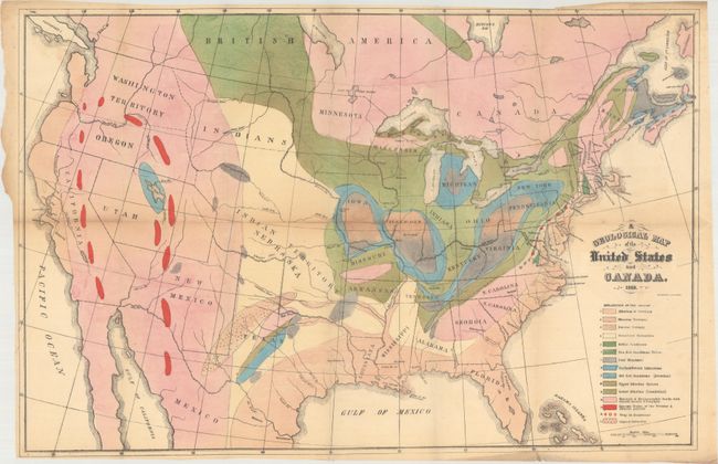
Includes Hitchcock's First Geological Map of the United States

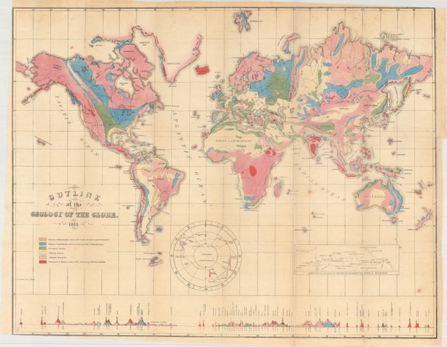
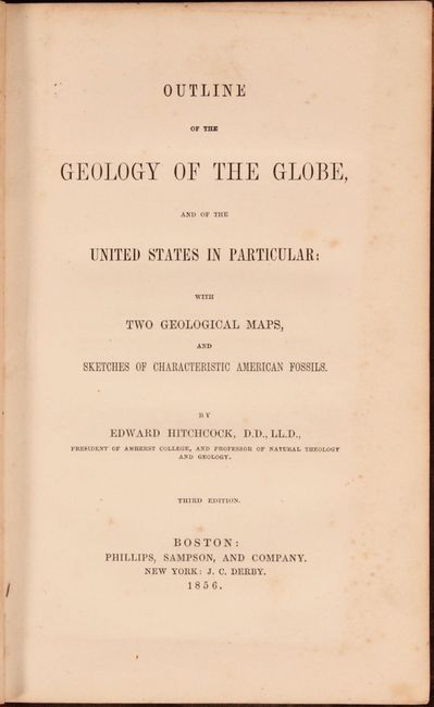
"[Maps with Report] A Geological Map of the United States and Canada [and] Outline of the Geology of the Globe", Hitchcock, Edward

Subject: United States & Canada, World

Period: 1856 (published)

Publication:

Color: Hand Color

Size:
5.5 x 8.7 inches
14 x 22.1 cm
Download High Resolution Image
(or just click on image to launch the Zoom viewer)

A. A Geological Map of the United States and Canada (24.1 x 15.8"). This is Hitchcock's landmark map of 1853. Essentially, it is a compilation of Lyell’s map for the eastern portion combined with M. Boue’s Geological Map of the World for the western portion modified by the author’s generalizations derived from the relations of geography to geology, as argued in the report. In this respect, he freely admits that such generalizations for the western US might be greatly erroneous. This map provides early detail of the geological formations. An explanatory key to the colors indicates fifteen geologic types. Condition: There is light toning primarily along the folds and a 2" fold separation near the center of the map image. (B)

B. Outline of the Geology of the Globe (23.3 x 18.3"). Drawn on Mercator's Projection, this map shows the entire world with a separate hemisphere of the "Supposed Antarctic Continent" that locates Wilke's Land, South Victoria, Enderby Land and Cook's sighting of 1774. This map uses six different colors to locate as many geological types. Along the bottom are the comparative heights of mountains and volcanoes aligned with the position on the map. Condition: There are a few spots of foxing and a 2.5" binding tear at right that has been closed on verso with archival tape. (B+)

These important geological maps are bound in the original report "Outline of the Geology of the Globe, and of the United States in Particular; with Two Geological Maps, and Sketches of Characteristic American Fossils," published by Phillips, Sampson & Company in Boston. Octavo, 136 pages, 6 plates, and 2 folding hand-colored geological maps. Hardbound in brown cloth with blind-stamped decorative elements and gilt title on spine. This work is notable for containing his first attempt at a geological map of the United States. His son C. H. Hitchcock also notes that "the part relating to the United States is the first attempt to show the distribution of rocks from the Atlantic to the Pacific border." It is uncommon to see the report and its two maps together.

References: Marcou & Marcou #4 & #41.

Condition:

The maps are issued folding and separated from the binding. See description for details on the maps and condition grades. Report text is mostly clean and tight with an occasional spot of foxing. The front hinge is starting and there is a small chip at the top of the spine. There is light wear to the covers with bumped edges. (B+)

Estimate: $1,000 - $1,300

Sold for: $750

Closed on 6/6/2018

Archived