Catalog Archive
Auction 168, Lot 112

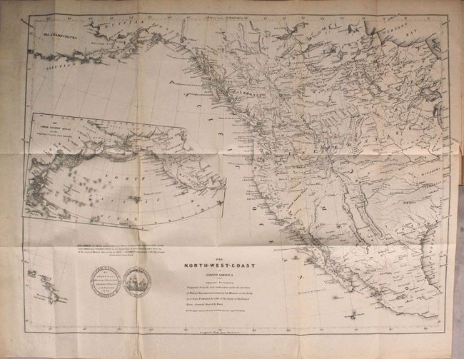
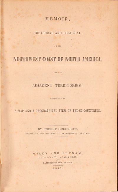
"The North-West-Coast of North America and Adjacent Territories... [in] Memoir, Historical and Political on the Northwest Coast of North America...", Greenhow, Robert

Subject: Western North America

Period: 1840 (published)

Publication:

Color: Black & White

Size:
22.1 x 16.2 inches
56.1 x 41.1 cm
Download High Resolution Image
(or just click on image to launch the Zoom viewer)

David H. Burr was a tremendously important figure in the mapping of the United States. He began his career surveying in New York in 1829. Beginning in 1833 he served as topographer of the United States Post Office, then Geographer for the House of Representatives, surveyor to the states of Florida and Louisiana, Geographer to the U.S. Senate and finally as Surveyor General of Utah Territory during the legal and jurisdictional disputes between Mormon leaders and the U.S. government.

When in 1836 David left as Topographer to the Post Office, his brother Henry A. Burr took over the position. Henry retained this title until his death in 1863. His cartographic output did not match his brother's, but he is known to have made the map "Disturnell's New Map of the United States and Canada Showing All the Canals, Rail Roads, Telegraph Lines and Principal Stage Routes" in the early 1850s.

Robert Greenhow was the translator and librarian to the Department of State, a leading authority on the Northwest and a strong advocate for American growth into that region. This map includes all of the western half of North America extending from Russian Possessions in Alaska, south to Acapulco, Mexico, east to Lake Michigan and west into the Pacific to include the Sandwich Islands. The Independent Republic of Texas shows S. Antonio de Bexar, Austin and names Ft. Alamo, which is rarely called out on maps, including other editions of this map. Other editions show Washington as the capital of Texas, but the town is not on this issue. Pre-Fremont geography is depicted in the West. The U.S. - Canadian boundary is undefined, reflecting Greenhow’s advocacy of American claims in the area. Locates Ashley's Lake and Lost and Inconstant Rivers. The Buenaventura River flows into the Swamp Lakes & Is., with the Sacramento River flowing from it. Large inset shows the North Pacific Ocean. Today's British Columbia is New Caledonia. A vignette shows the front and back of a medal struck at Boston in 1787 to commemorate the departure of ships Columbia and Washington for an early exploration by the U.S. to the Pacific Northwest. Drawn by David H. Burr, this map was also published as Sen. Doc. 174, 26th. Cong, 1st Sess. Still bound into the 228-page report. Octavo, hardbound in brown cloth with blind-stamped decorative elements on covers.

References: Phillips (Maps) p. 603; Wheat [TMW] #447.

Condition: B+

The map has light scattered foxing with a short binding tear at right that just enters the map image. Report text is tight with light scattered foxing. The front hinge is starting, the covers have light wear with bumped edges, and the top half of the spine backstrip is missing.

Estimate: $350 - $425

Sold for: $220

Closed on 6/6/2018

Archived