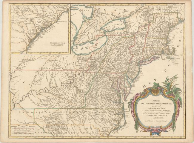
"Partie de l'Amerique Septentrionale, qui Comprend le Cours de l'Ohio, la Nlle. Angleterre, la Nlle York, le New Jersey, la Pensylvanie, le Maryland la Virginie, la Caroline", Robert de Vaugondy
Subject: Colonial New England & Mid-Atlantic United States
Period: 1768 (circa)
Publication: Atlas Universel
Color: Hand Color
Size:
24.5 x 18.8 inches
62.2 x 47.8 cm
Beautifully engraved large map of the colonies between the Ohio and Mississippi rivers and the Atlantic with an inset at upper left that continues the main map from Cape Fear south through the Carolinas and Georgia to F. St. Georges. It is based on the seminal map by John Mitchell, published in 1755, the same year this plate was initially engraved. The mapping of the trans-Allegheny and Great Lakes regions and in the interior of New England is of particular interest, for this shows some of the earliest accurate information of these regions incorporating data from the Mitchell, Evans and Fry-Jefferson maps. Also of great interest is the region known as the Forks of the Ohio (confluence of the Allegheny and Monomgahela rivers) and the location of French Fort Duquesne – the region hotly disputed during the French and Indian War. This is the second state with several changes, including the removal of final line below the title ("Avec Privilege 1755") and the 1763 Treaty of Paris boundary shown as a dotted line. Pennsylvania extends to take in most or present-day New York and in New England New-Hamp-Shire and Prov. De Sagadahock have been added. A handsome title cartouche engraved by Groux fills the Atlantic.
References: Cumming (SE) #295; McCorkle #755-37; Pedley #469; Sellers & Van Eel #718.
Condition: B+
Watermarked paper with very light soiling in the image and more noticeable soiling along the edges of the sheet.