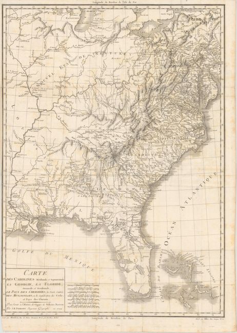
"Carte des Carolines Meridionale et Septentrionale, la Georgie, la Floride, Orientale et Occidentale, le Pays des Cherokees, la Vaste Contree des Muscogulges, ou la Confederation des Creks et Pays des Chataws", Poirson, Jean Baptiste
Subject: Eastern United States
Period: 1799 (dated)
Publication: Voyage dans les Parties Sud de l'Amerique Septentrionale...
Color: Black & White
Size:
17.4 x 24.3 inches
44.2 x 61.7 cm
This map is from a French edition of William Bartram's famous narrative Travels through North and South Carolina, Georgia, East and West Florida..., which was first published in 1791. The volume recounts his odyssey (1773-78) exploring the American Southeast and the plants and wildlife he encountered. He also describes his contacts with various Indian tribes including the Creek, Cherokee and Choctaw. The French editions are the only ones to contain the large map of the United States, and it depicts the region from the Mississippi River to the eastern seaboard. Cartographically, the topography and river systems are particularly well developed with settlement primarily confined to east of the Allegheny Mountains. Scores of Indian villages are located in the southwestern frontier (present-day Alabama and Mississippi) and Florida, and the entire Northwest Territory is called Nouvel Etat de Kentukey. Includes seven distance scales.
References: Howes #B223; Sabin #3871; Streeter Sale #1088.
Condition: B
Issued folding on watermarked paper with light scattered foxing and one short fold separation along the left border that has been closed on verso with archival material. There is a narrow left margin.