"[Lot of 3] Chart of the Society Isles... [and] Isles de la Reine Charlotte [and] A Chart of the Islands Discover'd in the Neighbourhood of Otaheite, in the Course of Several Voyages Round the World, Made by the Capns Byron, Wallis, Carteret, & Cooke...",
Subject: French Polynesia, Solomon Islands
Period: 1773-80 (circa)
Publication:
Color: Black & White
Captain James Cook (1728-1779) is best known for his three voyages to the Pacific (1768-71; 1772-75; and 1776-79). His discoveries radically changed the western understanding of the world in the late 18th century. He was the first to circumnavigate and chart New Zealand and provided the earliest European accounts of exploration along the eastern coast of Australia and the Hawaiian Islands. On February 14th, 1779, he was killed on Hawaii after attempting to kidnap the chief of the island.
Many contemporary accounts of Cook’s voyages, including charts and engravings, appeared in the late 18th century. The first official account of Cook’s first voyage was published in 1773 by John Hawkesworth in Volumes II and III of An Account of the Voyages Undertaken by the Order of His Present Majesty for Making Discoveries in the Southern Hemisphere... William Strahan and Thomas Cadell published the first official accounts of the second and third voyages in 1777 and 1784. Accounts of his exploration were subsequently translated into French, German, and Dutch.
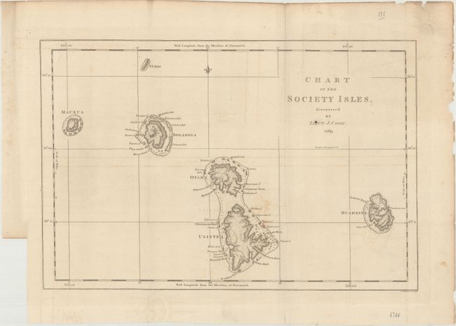
A. Chart of the Society Isles, Discovered by Lieut. J. Cook, by Captain James Cook, from An Account of the Voyages ... in the Southern Hemisphere, published 1773, (17.3 x 11.6"). This chart shows the western Society Islands of French Polynesia. The islands are here called Maurua (Maupiti), Bolabola (Bora Bora), Otaha (Tahaa), Ulietea (Raiatea), and Huaheine (Huahine). There is excellent coastal detail surrounding the islands, including soundings, anchorages, rocks, shoals, and several place names. This map was published in John Hawkesworth's "An Account of the Voyages." Engraved by J. Cheevers. Ref: Shirley (BL Atlases) G.HAWK-1a #19. Condition: Issued folding on a watermarked sheet with light offsetting. (B+)
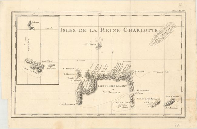
B. Isles de la Reine Charlotte, by Cook/Benard, from Relation des Voyages Entrepris par Ordre de Sa Majeste Britannique..., circa 1780, (15.3 x 9.3"). This chart depicts a small part of the extensive Solomon Islands located east of Papua New Guinea with an erupting volcano and an inset of Carteret Island. Condition: Issued folding with faint offsetting and a small light stain at bottom right. (A)
C. A Chart of the Islands Discover'd in the Neighbourhood of Otaheite, in the Course of Several Voyages Round the World, Made by the Capns Byron, Wallis, Carteret, & Cooke..., by William Whitchurch, from An Account of the Voyages…, published 1773, (20.4 x 9.5"). This chart documents the important exploratory voyages in the vicinity of Tahiti. The tracts of Byron, Wallis, Carteret and Cook are carefully shown on the chart. Condition: Issued folding on a watermarked sheet with light offsetting, faint toning, and minor soiling. (B+)
References:
Condition:
See description above.