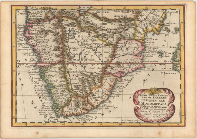
"T Land en de Kusten van de Kaffers, de Ryken van Monomotapa, Monoemugi, enz. Getrokken uit Sanutus, enz.", Sanson, Nicolas
Subject: Southern Africa
Period: 1705 (published)
Publication: Algemeene Weereld-Beschryving…
Color: Hand Color
Size:
11.2 x 7.9 inches
28.4 x 20.1 cm
This charming map of the southern part of Africa is fully engraved with mountains, several large rivers, and lakes. The kingdom of Monomotapa covers most of the interior, and a city of the same name sits on the bank of the Spiritus River. Rivers flowing from the Mountains of the Moon (Montagnes de la Lune) feed an unnamed lake at top that appears to be the mythical Lake Zaire. The coast is dense with place names.
This map appeared in Algemeene Weereld-Beschryving, nae de Rechte Verdeeling der Landschappen, Plaetsen, Zeeën, Rivieren, &c. Geographisch, Politisch, Historisch, Chronologisch en Genealogisch, a Dutch edition of A. Phérotée de la Croix's Nouvelle Methode Pour Apprendre Facilement la Geographie Universelle, which first appeared in 1690. The Dutch edition was published by Francois Halma and included 98 maps and views. Halma acquired many of the plates for Algemeene Weereld-Beschryving from Joannes Ribbius, who had enlisted the services of engraver Antoine de Winter to make copies of the maps in Nicolas Sanson's quarto atlases of the four continents. De Winter made very few geographical changes and maintained the attribution to Sanson on the newly engraved plates. Halma supplemented the Sanson maps with about a dozen new maps engraved in the same style as Sanson's, without any attribution on the maps, as well as 23 panoramic views of famous cities around the world.
References:
Condition: A
A crisp impression with marginal soiling, light toning along the edges of the sheet, and a few minor damp stains along the bottom edge of the sheet.